
If you’re managing a construction project in Tucson or anywhere else across Arizona and you’re trying to figure out whether Tucson construction drone photography makes sense for your site, you’re probably not short on questions.
How much does it cost? What do you actually get? Do you need permits near Tucson International Airport or Davis-Monthan AFB? What happens when monsoon season rolls in and storms pop up at 3 PM?
Tucson construction drone photography is something Desert Drones LLC has been doing for over five years, and the questions contractors, developers, and project managers ask us are almost always the same. Instead of making you dig through service pages to piece together answers, we’ve put everything in one place.
These are the real questions people ask before booking aerial documentation for a construction project.
What Is Construction Drone Photography and Why Do Contractors Use It?
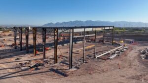
Construction drone photography uses FAA-certified drone pilots to capture regular aerial photos, video, and mapping data throughout the lifecycle of a project.
It provides contractors, developers, and project managers with a consistent visual record from angles that ground-level photography simply can’t capture.
Common uses include:
- Milestone documentation
- Stakeholder reporting
- Lender updates
- Safety monitoring
- Before-and-after comparisons
- Dispute resolution
For larger projects, drone photography also replaces the expense and complexity of helicopter or fixed-wing aerial imaging.
What Types of Construction Projects Use Aerial Drone Documentation?
Almost every type of construction project benefits from aerial documentation, including:
- Commercial ground-up construction
- Residential subdivisions
- Industrial developments
- Warehouse construction
- Infrastructure projects
- Solar farm construction
Desert Drones works with general contractors, developers, civil engineers, and project managers throughout Arizona.
In Tucson, this includes projects along the Houghton Road growth corridor and industrial development along I-10. In the Phoenix metro area, drone documentation is increasingly common throughout Scottsdale and the West Valley.
If your project evolves through multiple phases, aerial documentation provides an invaluable historical record.
How Often Should I Schedule Drone Flights?
The ideal schedule depends on project activity.
Weekly Flights
Best for fast-moving commercial construction where significant progress occurs every few days.
Biweekly Flights
An excellent balance for standard commercial and residential developments.
Monthly Flights
Ideal for infrastructure projects, phased developments, and longer construction timelines.
The most important factor is consistency. Flying identical flight paths at the same angles creates meaningful month-over-month comparisons that random aerial images cannot provide.
What Deliverables Do I Receive?
Standard construction drone photography packages typically include:
- High-resolution aerial photography
- Aerial video
- Edited progress comparison images
- Consistent waypoint photography
For projects requiring additional spatial data, Desert Drones also produces orthomosaic maps that can be measured and imported into CAD or GIS software.
Annotated progress reports are also available for stakeholder or lender distribution.
Most aerial construction progress photos are delivered within a few business days.
What’s the Difference Between Aerial Photos and an Orthomosaic Map?
A standard aerial photograph provides a high-quality visual overview of a construction site for documentation, reporting, and marketing.
An orthomosaic map is much more detailed.
Created from hundreds of overlapping drone images, it is corrected for distortion and georeferenced so every pixel corresponds to a real-world GPS location.
Orthomosaic maps allow teams to:
- Measure distances
- Calculate site areas
- Track grading progress
- Estimate stockpile volumes
- Import data into CAD and GIS platforms
For routine progress documentation, aerial photography is often sufficient. For measurement and analysis, orthomosaic mapping becomes an essential tool.
How Much Does Construction Drone Photography Cost in Tucson?
Pricing depends on project size, deliverables, and visit frequency.
Recurring weekly or biweekly documentation packages are customized based on:
- Site size
- Flight frequency
- Deliverable requirements
- Project duration
Orthomosaic mapping and specialized reporting may be added as needed.
The most accurate way to receive pricing is by providing your project location, scope, and reporting requirements.
How Long Does It Take to Receive Photos and Video?
Standard turnaround time is a few business days.
Most edited aerial photos and videos are delivered within three business days and formatted for immediate use in reports or presentations.
Rush delivery can often be accommodated for lender inspections, owner meetings, or insurance documentation.
Orthomosaic mapping generally requires additional processing time.
Do You Need FAA Authorization to Fly Over Construction Sites?
Yes.
All commercial drone operations require an FAA Part 107 Remote Pilot Certificate.
Many Tucson construction sites also fall within controlled airspace requiring LAANC authorization or FAA approval before flight.
Does Summer Heat or Monsoon Weather Affect Drone Flights?
Arizona weather absolutely influences flight scheduling.
High temperatures reduce battery performance, making early morning flights the preferred option during summer months.
Monsoon season also introduces rapidly developing afternoon storms.
For safety reasons, Desert Drones does not operate during:
- High winds
- Rain
- Lightning activity
Weather flexibility is built into recurring documentation schedules to maintain consistent project coverage.
How Do I Know If a Drone Company Is Properly Licensed and Insured?
A professional drone provider should be able to provide:
- FAA Part 107 certification
- Authorization documentation
- Liability insurance certificates
Desert Drones carries liability insurance, maintains all required FAA credentials, and holds waivers for specialized operations.
The company is also a two-time Arizona Daily Star Readers’ Choice Award winner for Best Aerial Photographer (2023 & 2024).
Do I Need to Be On-Site During the Drone Flight?
Not necessarily.
The first visit often benefits from coordination with the site superintendent or project manager to establish coverage priorities.
After that, recurring flights typically operate independently using established flight paths and documentation standards.
Most clients simply receive their completed deliverables remotely within 24–48 hours.
Can You Cover Multiple Construction Sites?
Yes.
Desert Drones provides construction drone photography throughout many locations.
Services are available in Arizona, Colorado, New Mexico, Texas, and Nevada.
For developers and contractors managing multiple projects, standardized deliverables and coordinated scheduling create consistent documentation across every location.
Ready to Set Up Aerial Documentation for Your Tucson Construction Project?
The best time to begin aerial documentation is before the first footing goes into the ground, but projects already underway can still benefit from consistent progress photography.
Contact Desert Drones LLC
Desert Drones LLC – The Southwest’s Premier Aerial Photography & Drone Videography Company
📞 (520) 214-8133
🌐 desertdronesllc.com
📸 Instagram: @desertdronesllc