
Las Vegas is building — warehouses across North Las Vegas and Apex, master-planned phases in Summerlin and Cadence, big-box retail, and multifamily from Henderson to Skye Canyon. Drone progress documentation gives owners, GCs, and lenders the same view of the site every week. We fly it FAA-certified, insured, and on schedule.
FAA Part 107 Certified · Fully Insured · LAANC Authorized · 5.0★ from 271 Google reviews
Desert Drones provides FAA Part 107–certified construction drone services across the Las Vegas valley — scheduled progress aerials, survey-grade orthomosaic site maps with contour data, milestone and draw-inspection documentation, and marketing footage of active projects. In August 2025 we documented the new Costco big-box build in Las Vegas on video, and in spring 2026 we delivered orthomosaics and contour files across three valley sites for a Las Vegas civil-engineering firm — the same documentation we deliver for ground-up builds across southern Nevada.
One flight, the whole site — here's what a progress package covers.
Organized, dated, shareable — documentation your PM can actually use.
Real Las Vegas projects, not stock — a big-box retail build on video, survey-grade mapping across three valley sites, and pre-construction documentation in Henderson.
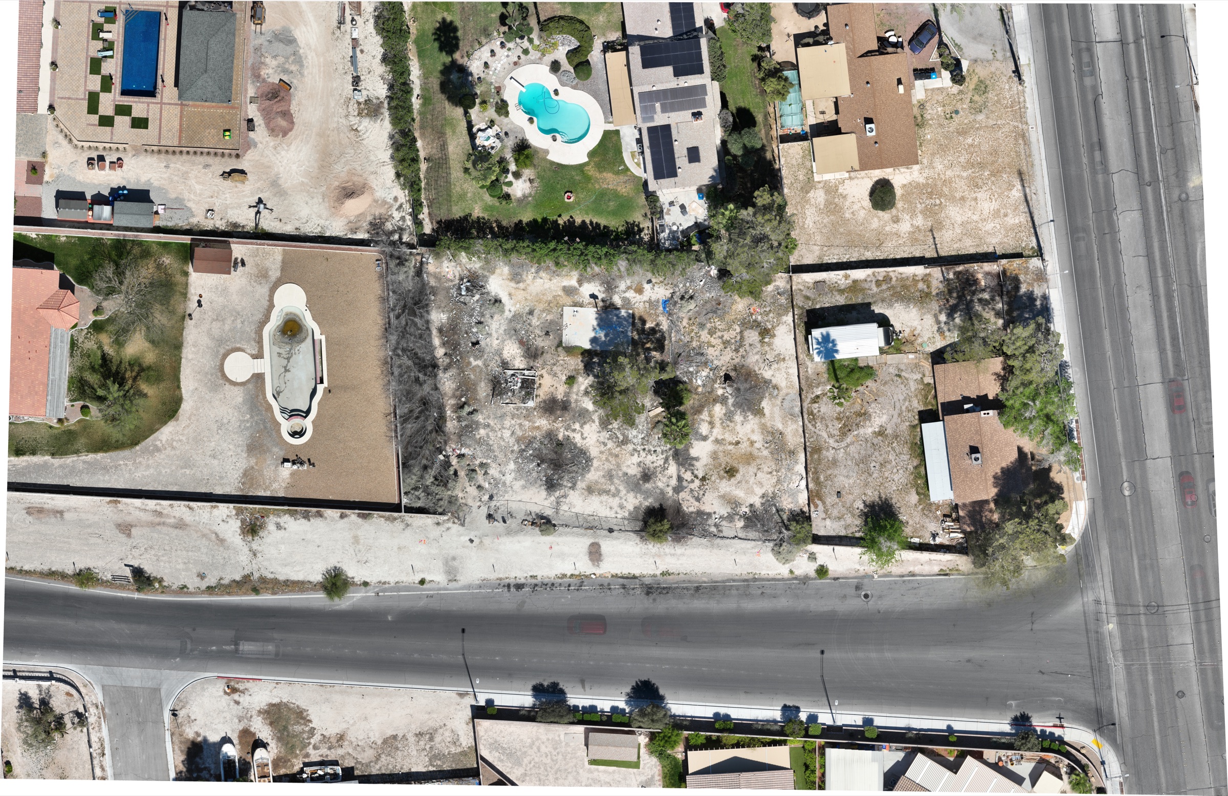
A real deliverable — this orthomosaic plus DXF contours and a digital surface model went to a Las Vegas civil-engineering firm in March 2026, one of three valley sites we mapped for them.
LV VALLEY · MAR 2026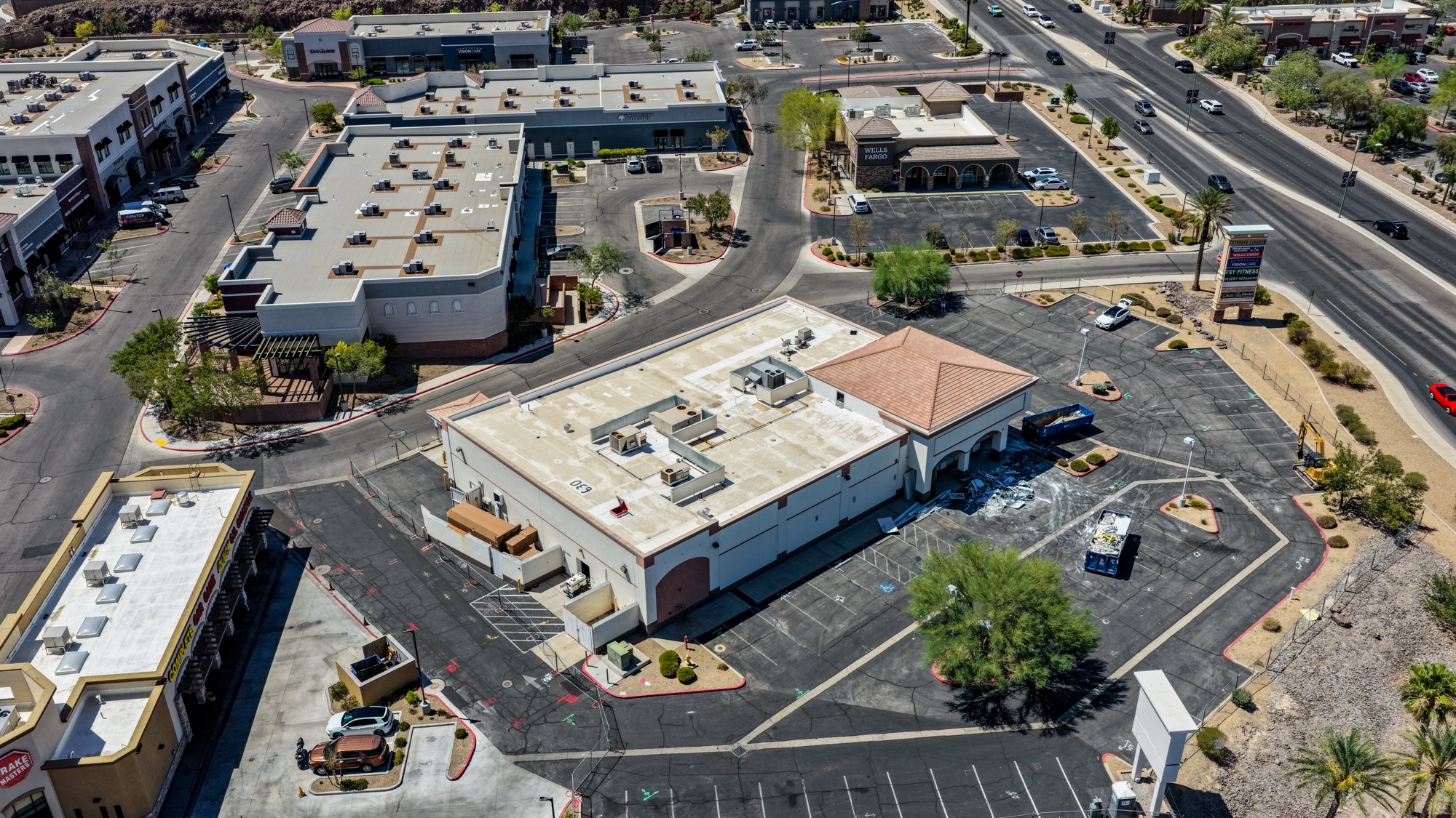
Our July 2026 Henderson shoot — full site and roof-condition documentation of a commercial redevelopment before work begins. The baseline record every renovation should start with.
HENDERSON · JUL 2026
We documented the new Costco build in Las Vegas in August 2025 — the video is below. Large-format retail and tilt-up projects are where the aerial view earns its keep.
LAS VEGAS · AUG 2025The Las Vegas projects above were flown by our licensed pilots on the ground in the valley, with LAANC authorization pulled under the valley's controlled airspace. Ground-up build, redevelopment, or master-planned phase — the documentation package is the same discipline.
Real Las Vegas construction work — press play.
Set the schedule once — then the documentation just shows up.
Send the site plan and what you need documented — progress, orthos, milestones, marketing. We scope the flight plan and cadence.
Same angles every flight, LAANC pulled ahead, flight windows planned around summer heat and spring wind.
Photos edited and organized by date; orthos, contours, and DSMs processed; clips cut for stakeholder updates.
Everything lands in a shared link your whole team can use, flight after flight.
The Las Vegas building boom has specific documentation demands — we fly them.
North Las Vegas and Apex are one of the fastest-growing warehouse markets in the country. Big footprints need the wide view — phasing, tilt-up sequencing, and laydown in one frame.
Summerlin, Cadence, Inspirada, Skye Canyon — community-scale projects need phasing, roads, amenities, and lot progress documented month over month.
Summer site flights happen in morning windows — better light, better battery performance, and crews are already on site. We build the cadence around it.
Harry Reid's Class B shelves, North Las Vegas Airport, Henderson Executive, and Nellis AFB cover most of the valley. We pull LAANC before every flight.
Construction documentation has to hold up — to the lender, the owner, and sometimes the courtroom. That takes a licensed, insured operation.
Construction clients often bundle these — same Las Vegas pilots, often the same flight.
Weekly, biweekly, or milestone-based — most Las Vegas projects settle on a biweekly cadence with extra flights at major milestones and draws.
Yes — survey-grade orthomosaics, DXF contour lines, and digital surface models. We delivered exactly that package across three Las Vegas valley sites for a civil-engineering firm in spring 2026.
Most of the valley sits under controlled airspace. We hold LAANC authorizations and plan flights legally under the Class B shelves; areas inside Nellis restricted airspace require advance coordination and some are simply no-fly.
No — it moves them. We fly morning windows in summer for battery performance and clean light, and build weather flex into the schedule for spring winds.
FAA Part 107 certified and insured with $2M liability coverage; certificate of insurance available for your GC or owner requirements.
Your project team gets full usage rights — internal reporting, lender packages, and marketing.
Rated 5.0★ from 271 verified Google reviews across our locations.
John and team are the consummate professionals! Very reliable, quick, and high quality deliverables!
Professional, efficient, and easy to work with. The team delivered clean, high-quality aerials and communicated clearly throughout the project.
Needed work done quickly for drone photography. They responded quickly, knew exactly what was required, and explained it well — great customer service.
John was a professional and very knowledgeable. He made the process of getting drone footage seamless and did an exceptional job.
Absolutely amazing experience with Desert Drones. They did a shoot for my business and made my product really speak for itself!
John is a true professional. Every time we need drone photography or videography done, he is excited to take on the project.
Send the site plan and your cadence — we'll scope the flight plan and get your team the first dated progress set this week.