
Based in Phoenix, we fly the sites that are too big, too tall, or too dangerous to inspect on foot — manufacturing plants and heavy-industrial facilities across the Valley, and aggregate yards and mine sites across Arizona. One flight gives you a measurable map of the whole operation: stockpile volumes, facility condition, and the documentation your operations and compliance teams actually need.
FAA Part 107 Certified · Fully Insured · LAANC Authorized · 5.0★ from 271 Google reviews
Desert Drones is an FAA Part 107–certified drone services company serving industrial and mining operations across Arizona from a Phoenix base — aerial facility and plant inspection, stockpile and earthwork volumetrics, mine and aggregate-site mapping, and environmental-compliance documentation. We deliver orthomosaic maps, measured volume reports, and high-resolution inspection imagery, and we handle the airspace waivers that industrial sites near airports require.
Whether it's a manufacturing plant or a hundred-acre aggregate yard, a drone captures it faster, safer, and in more measurable detail than any ground survey.
Measurable data your operations, engineering, and compliance teams can all work from — not a folder of photos.
Our local proof is facility-led — the biggest industrial sites in the Valley — backed by recurring aggregate-volumetric programs at operations across the state.
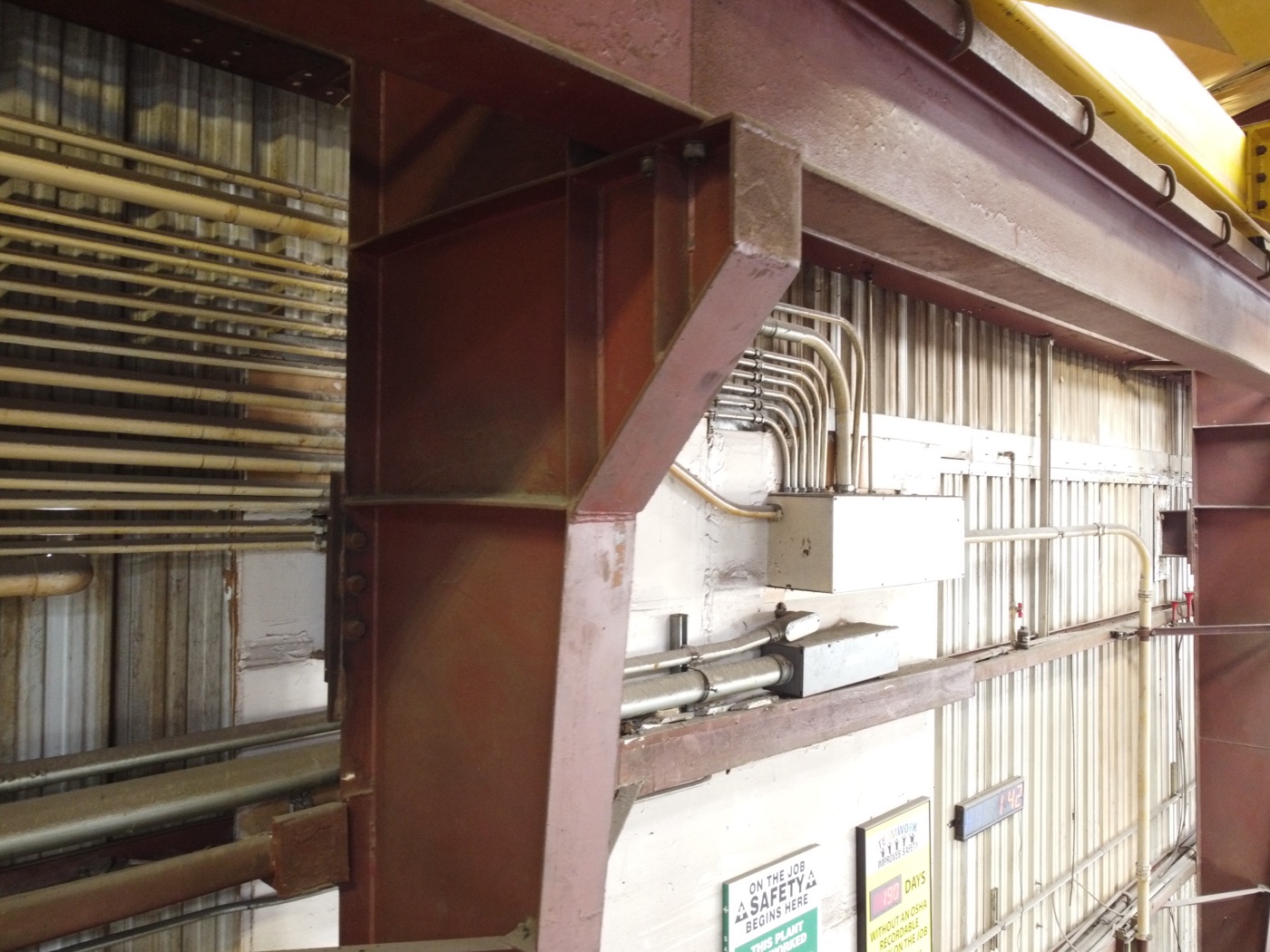
At a Glendale steel-decking manufacturing plant we documented the roof structure, structural steel, and plant floor across 400+ frames — heavy-industrial inspection imagery captured without pulling crews off the line.
HEAVY INDUSTRY · PHOENIX METRO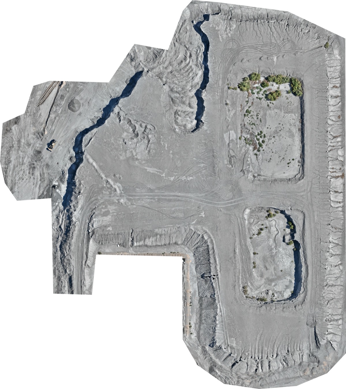
For a Goodyear aggregate operation inside Phoenix Goodyear Airport's controlled airspace, we flew a stockpile-volumetric survey under an FAA Class D waiver — one main pile measured at roughly 228,000 cubic yards, delivered as a stitched orthomosaic and annotation report.
VOLUMETRICS · PHOENIX METRO
Beyond the Valley we run recurring stockpile-inventory programs for aggregate and mine operations across Arizona — Gila Bend, Graham County, and the northern part of the state — flying the same repeatable pattern each visit so the cubic-yard numbers stay comparable month to month.
VOLUMETRICS · STATEWIDEStraight talk on geography: our heavy-industrial facility work is Phoenix-metro (Glendale and Goodyear among them), while our aggregate and mine-site volumetric programs run at operations across the state — Gila Bend, Graham County, and northern Arizona. We're based in Phoenix and mobilize statewide for mining and industrial sites.
Most operations set us up once on a recurring schedule and let it run — here's the path.
Boundary, what you need — volumes, inspection, mapping — and a cadence: one-time, monthly, or quarterly. We confirm any airspace waivers the site needs.
Repeatable flight pattern, ground-control where measurement accuracy demands it, and all authorizations in hand before we launch.
Orthomosaics stitched, volumes calculated against a documented base plane, equipment anomalies flagged.
Full deliverables within 48 hours by shared link, with every prior capture archived for reconciliation and compliance.
Flying heavy-industrial and mining work in Arizona takes more than a drone — here's what we handle.
Some sites sit in controlled airport airspace — we've flown aggregate volumetrics under a Class D waiver at a Valley airport. We do the FAA paperwork so your survey never stalls.
Summer surface heat and thermal turbulence degrade imagery and stress equipment. We fly Arizona sites in early-morning windows for clean data and safe operations.
Inventory and reconciliation need consistency. We fly the same pattern every visit so your cubic-yard numbers are comparable month to month, not one-off estimates.
Active pits and plants are big, dusty, and moving. We plan flight paths and timing around haul traffic and crews, and carry full liability coverage for active-site work.
On a Valley job, the difference between a licensed pro and a hobbyist is legal, insurable, and visible in the deliverables.
Industrial clients often bundle these — same Part 107 team, same mobilization when it makes sense.
Yes. We've flown aggregate volumetrics under an FAA Class D airport waiver, and we handle the LAANC or waiver paperwork for whatever airspace your site sits in.
We calculate cut/fill against a documented base-plane method and add ground control where accuracy demands it — accurate enough for inventory, reconciliation, and reporting.
Yes — many operations put us on a monthly or quarterly schedule so their volume numbers are consistent and comparable, which is where drone volumetrics beats occasional ground surveys.
Yes. We image rooftops, structural steel, stacks, and equipment from the air at a safe distance while the plant runs — no man-lifts, no production stoppage.
Absolutely. We're Phoenix-based but mobilize to mine and aggregate sites across Arizona, from Gila Bend to Graham County to the northern part of the state.
FAA Part 107 certified and fully insured, with certificates of insurance and additional-insured endorsements available for site requirements.
Rated 5.0★ from 271 verified Google reviews across our locations.
John and team are the consummate professionals! Very reliable, quick, and high quality deliverables!
Professional, efficient, and easy to work with. The team delivered clean, high-quality aerials and communicated clearly throughout the project.
Needed work done quickly for drone photography. They responded quickly, knew exactly what was required, and explained it well — great customer service.
John was a professional and very knowledgeable. He made the process of getting drone footage seamless and did an exceptional job.
Absolutely amazing experience with Desert Drones. They did a shoot for my business and made my product really speak for itself!
John is a true professional. Every time we need drone photography or videography done, he is excited to take on the project.
Tell us the operation and what you need measured or inspected — we'll confirm any airspace waivers and get you a quote.