
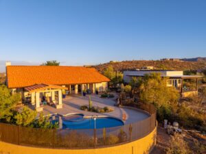
El Paso’s real estate market has some natural advantages that most markets can’t touch. You’ve got the Franklin Mountains running right through the city, the Rio Grande curving along the border, and neighborhoods from historic Kern Place to sprawling luxury developments in West El Paso—all set against a landscape that looks completely different from above.
The problem? Standard listing photos taken from street level don’t show any of that.
Buyers scrolling through Zillow can’t tell whether a home backs up to mountain views or sits in the middle of a dense neighborhood grid. Drone photography for El Paso realtors changes that equation entirely. Aerial photos and video put the full picture in front of buyers—the lot size, the surrounding landscape, and the property’s proximity to landmarks—before they ever schedule a showing.
Desert Drones LLC provides FAA-certified drone photography for El Paso real estate listings, giving agents the aerial content their listings need to stand out in a competitive market.
Why El Paso Real Estate Benefits from Aerial Photography
El Paso sits in a landscape that’s genuinely hard to capture from the ground.
Franklin Mountains State Park—one of the largest urban parks in the country—forms a dramatic backdrop for neighborhoods across the east and west sides. Homes in areas like Coronado Hills, Kern Place, and the upscale developments along North Mesa have mountain views that simply don’t show up in a standard exterior photo.
Neither does the lot size, the pool layout, or how close a property sits to major corridors like I-10 or Loop 375.
The border city dynamic also means El Paso draws buyers from Juárez and across the Southwest who are often researching properties remotely. A buyer in Dallas or Phoenix can’t drive by a listing on the weekend—they’re making decisions based entirely on what they see online.
Aerial photos and video provide the spatial context those buyers need to move forward with confidence.
Upper Valley and Luxury Properties
Luxury listings along the Upper Valley—near the Rio Grande and the historic agricultural estates that have been subdivided into high-end residential lots—are especially well suited to aerial coverage.
A property that sits on several acres beside the river tells a far more compelling story from above than from the front curb. Buyers can immediately see:
- Property boundaries
- Mature landscaping
- Relationship to the Rio Grande
- Outdoor amenities
- Franklin Mountain views
The Hueco Mountains to the east and the Juárez Mountains across the border add even more visual context that only makes sense from the air.
Commercial Properties and New Development
Commercial real estate throughout El Paso also benefits from professional drone photography.
Warehouses near border crossing infrastructure, office buildings along Airway Boulevard, and retail centers on North Mesa Street all have features that are difficult to appreciate from ground level, including:
- Parking capacity
- Traffic access
- Highway proximity
- Surrounding development
- Property scale
As El Paso continues expanding across the Lower Valley and East Side, builders can also use aerial imagery to market new developments before landscaping and streetscapes are complete.
How Drone Photography for El Paso Listings Works
Step 1: Booking and Airspace Coordination
Desert Drones LLC handles all FAA airspace coordination before every flight.
Because El Paso includes controlled airspace around El Paso International Airport (ELP), our pilots obtain all necessary LAANC authorizations and ensure every mission complies with FAA Part 107 regulations.
You don’t have to manage any paperwork—we take care of it.
Step 2: The Shoot
On shoot day, our pilot evaluates the property’s strongest selling features, including:
- Mountain views
- Lot size
- Pools
- Casitas
- Outdoor living spaces
- Commercial access points
The drone captures multiple perspectives, including:
- Wide establishing shots
- Mid-altitude property views
- Detailed feature photography
- Smooth cinematic video (when requested)
Step 3: Editing and Delivery
Every image is professionally edited and color corrected.
You’ll receive:
- High-resolution aerial photographs
- MLS-ready files
- Professionally edited aerial video
- Standard delivery formats compatible with major listing platforms
What to Expect on Shoot Day
Most residential properties take approximately one hour to photograph.
Larger homes, luxury estates, commercial properties, and multi-acre parcels may require additional flight time.
Because El Paso experiences spring winds and summer heat haze, morning appointments generally provide the cleanest lighting and smoothest flying conditions. However, we work around listing schedules whenever possible.
Who Uses Drone Photography in El Paso?
Residential Realtors
Professional aerial imagery helps agents win more listings and showcase homes more effectively.
Whether marketing an entry-level home or a luxury estate, aerial photography provides a competitive advantage.
Commercial Real Estate Brokers
Commercial buyers appreciate seeing:
- Building access
- Parking layouts
- Traffic flow
- Nearby highways
- Property context
Drone imagery helps communicate these details immediately.
Developers and Builders
Drone photography provides excellent marketing materials for:
- New subdivisions
- Custom homes
- Model homes
- Investor presentations
- Sales centers
Even projects still under construction benefit from aerial progress imagery.
Property Managers
Apartment communities and HOA-managed developments use aerial photography to:
- Market vacancies
- Update websites
- Showcase amenities
- Create marketing materials
- Document large properties
Why Choose Desert Drones LLC?
Desert Drones LLC is fully FAA Part 107 certified, allowing us to legally perform commercial drone operations throughout Arizona, New Mexico, Texas, Nevada, and the Southwest.
Our pilots understand the unique airspace considerations surrounding El Paso International Airport and the U.S.–Mexico border while providing safe, fully compliant operations.
Unlike hobby drone operators, we deliver professional-quality aerial photography designed specifically for real estate marketing.
What You Receive
Every project includes professionally edited aerial imagery ready for immediate marketing.
Services include:
- MLS-ready aerial photos
- Cinematic aerial video
- Residential real estate photography
- Commercial property photography
- Luxury property marketing
- Builder and developer aerial imagery
Whether you need a single listing photographed or ongoing support across multiple properties, Desert Drones LLC is ready to help.
Frequently Asked Questions
Do I need permits for drone photography?
No. Desert Drones LLC handles all FAA airspace authorizations and LAANC approvals required for each flight.
Can aerial photos be uploaded to the MLS?
Yes. All photos are delivered in high-resolution formats compatible with MLS systems and major real estate websites.
What’s the best time of year for drone photography?
Drone photography can be performed year-round in El Paso.
Morning flights generally provide the best lighting while minimizing wind and atmospheric haze.
What if the property is near El Paso International Airport?
Many properties fall within controlled airspace.
Desert Drones LLC manages all FAA approvals and determines flight eligibility before scheduling.
Can I order aerial video along with photos?
Absolutely.
Many agents choose both aerial photography and cinematic drone video to maximize online engagement and showcase luxury or large properties.
Ready to Elevate Your El Paso Listings?
Professional drone photography helps buyers understand a property’s full potential before they ever schedule a showing.
Whether you’re marketing a luxury estate, commercial property, new construction community, or residential listing, Desert Drones LLC delivers FAA-certified aerial photography that helps your listings stand out.
Contact Desert Drones LLC
Desert Drones LLC
Phone: (520) 214-8133
Email: JOHN@DESERTDRONESLLC.COM
Website: https://desertdronesllc.com
Instagram: https://www.instagram.com/desertdronesllc
Serving Arizona, New Mexico, El Paso, Las Vegas, and the Southwest with professional FAA-certified aerial photography and drone videography services