
If you’ve ever stood on the edge of a dirt pad in Marana with a measuring wheel and a clipboard, you already know why teams switch to Arizona aerial mapping drone services for site data. It’s faster, it’s safer, and the number you walk away with at the end of the day is the kind of number you can actually plan around.
Drone mapping has grown up a lot in the last few years. What used to be a “neat picture from above” is now a real measurement tool — one that fits cleanly into the workflows construction teams, solar developers, real estate teams, and engineers already use.
Here’s a walkthrough of what mapping flights look like across Tucson and Phoenix, what they actually deliver, and how to time them around our weird Arizona calendar so you get the cleanest data possible.
What Arizona aerial mapping drone services actually do for a site
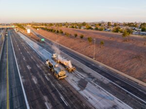
A mapping flight is not the same as taking a few aerial photos and calling it a day. The drone flies a planned grid at a set altitude, captures hundreds (sometimes thousands) of overlapping geotagged images, and stitches everything into a single, scaled-down version of your site you can measure on a screen.
That output usually shows up as a few different files. The orthomosaic is the flat, top-down image with no lens distortion, where one pixel equals a real-world distance. The digital surface model captures every bump on the ground — buildings, equipment, vegetation, stockpiles. Pulled together, you can use them to track grading, calculate cut-and-fill volumes, watch a pad evolve week to week, or pull a clean base layer for a site plan.
Across our service area, this is showing up everywhere — drone mapping for Tucson construction sites along the Houghton Rd corridor, aerial orthomosaic mapping Phoenix builders use across the Loop 303 corridor, large solar farms outside Marana, and master-planned communities pushing into Vail and Sahuarita. If you’re curious how this fits with our drone services for Arizona construction projects, it pairs directly with our progress-documentation work — same flight, more data.
How accurate is drone aerial mapping in Arizona?
This is usually the first question we get from engineers, and it’s a fair one. Short answer: more accurate than most people expect.
A well-run mapping flight using RTK-enabled drones in Arizona typically lands at 1–3 cm horizontal accuracy and a few centimeters vertical, depending on conditions. When ground control points are placed and surveyed in, accuracy tightens further — that’s the workflow we lean on for projects that need to line up with engineering drawings or track volumetrics over time.
A few things move the needle either way. Camera and sensor quality matter. So does flight altitude — lower flights see more detail, higher flights cover ground faster. Ground control points (GCPs) raise the ceiling on what’s possible, especially across larger sites. And, this being Arizona, weather plays a real role: midday heat shimmer, dust kicked up by wind, and low-angle sun all affect image sharpness.
For projects that need survey-grade legal accuracy — boundary work, plats, anything filed with the county — drone data is a strong companion to a licensed surveyor’s work, not a replacement for it.
For everything else (volumes, progress, planning, internal records), it’s usually more than enough.
How long does an aerial mapping flight take?
The mission itself is fast. A typical residential or small commercial site in Tucson runs 20–45 minutes of flight time, sometimes split across two or three batteries. A mid-size construction site or a 40-acre solar parcel runs longer, but most projects under 100 acres can be flown in a single morning.
Processing is the part most people forget about. Once the images are off the drone, they go through photogrammetry software that aligns the photos, builds the point cloud, and renders the orthomosaic and elevation model. For a standard project, you can expect deliverables back within a couple of business days. For our inspection clients, we hold a 24–48 hour turnaround as the standard.
The bigger time savings is the part you don’t see. A walking survey of the same area might take a small crew several days. A drone flight handles it in a single window — and because the data is timestamped and georeferenced, the second visit a month later lines up cleanly with the first. That repeatability is one of the reasons month-over-month flights have become a normal line item on construction budgets across the Phoenix metro area, from Mesa and Gilbert out through Buckeye and Surprise.
What deliverables come with a drone aerial mapping project?
This is where mapping starts to feel different from regular drone photography. You’re not getting a folder of pretty photos. You’re getting a dataset.
A standard package usually includes the orthomosaic (high-resolution top-down map), a digital surface model and digital terrain model, a 3D point cloud, and any volumetric measurements you’ve requested. We can also produce contour lines, cross-sections, and exportable files that drop straight into the platforms most Arizona teams already use — DroneDeploy, Pix4D, AutoCAD, and similar.
For solar and roofing work, the drone topographic mapping Arizona crews ask for usually pairs with thermal data. That gives you both the visual map and a separate layer showing temperature variations across the array or roof — useful for spotting underperforming panels or wet insulation before it spreads.
We also build the deliverables to be repeatable. The flight path is saved, the camera settings are saved, and the next flight over the same site retraces the same lines. That makes month-over-month comparisons clean, which is a huge deal for construction tracking, environmental monitoring, and any project where you want to see exactly what changed.
When the Arizona calendar actually matters for mapping flights
Most parts of the country can fly mapping missions year-round and not think twice. Arizona has a handful of windows where timing matters more than people expect.
Late spring through early summer is generally the cleanest light: long daylight hours, low humidity, minimal cloud cover. Once monsoon season ramps up in July, afternoon flights get tricky — high winds, dust, and pop-up storms can ground a mission with very little warning. We usually shift mapping flights to early-morning windows during monsoon and keep an extra day of slack in the schedule.
Peak summer heat (think mid-June through early August at midday) also affects image quality. Heat shimmer off pavement and bare ground can show up in the imagery, especially on dark surfaces and metal roofs. For thermal work, that actually helps in some cases. For straight orthomosaics, it’s a reason to fly first thing in the morning.
Winter is generally great in Tucson and the Phoenix Valley — cool, dry, and stable. Up around Flagstaff and Prescott, snow and high winds can swap the calendar around, so northern Arizona flights tend to cluster in the shoulder seasons.
What to look for in a local mapping provider
Not every drone pilot is a mapping pilot. Mapping has its own learning curve — flight planning software, GCP workflows, photogrammetry processing, and the patience to actually QC the data before it goes out.
A few things worth asking any provider you’re considering: Are they Part 107 certified with current LAANC approvals (a must in restricted Tucson and Phoenix airspace)? Do they carry liability insurance? Can they fly repeatable flight paths for month-over-month comparisons? Do they have local pilots, or is someone driving in from out of state? Locality matters more than people think — a Tucson-based crew knows that a 6 a.m. summer flight is the difference between clean data and useless data.
Desert Drones LLC has been doing this work across Arizona aerial photo and video projects for over five years, with two-time Arizona Daily Star Readers’ Choice wins for Best Aerial Photographer (2023 and 2024). We carry $2M liability coverage, hold FAA waivers where they’re needed, and run pilots locally in every major metro we serve.
Ready to get a mapping flight on the schedule?
If you’ve got a site that needs measured, tracked, or documented over time, we’d love to help.
Whether it’s a 5-acre infill in midtown Tucson, a 200-acre solar farm in Pinal County, or a master-planned community pushing east of Phoenix, the workflow is the same — and the data lands on your desk fast.
Reach out through our contact page for a quote, or head over to the Desert Drones LLC homepage to see the full service list. We’ll talk through the site, the timing, and the deliverables you actually need.