
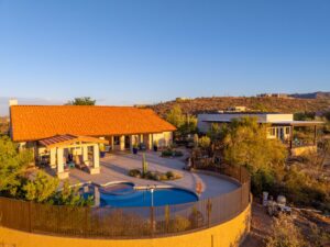
DFW is one of the hottest real estate markets in the country, and aerial photography has quickly become a standard expectation for buyers shopping anything above the entry-level price point. If you’re listing a Southlake estate, a Frisco new-build, or a commercial property near the Dallas North Tollway, buyers and their agents are looking for aerial images before they ever schedule a showing. Listings without professional drone photography often generate less interest and face tougher negotiations.
Desert Drones LLC provides FAA-certified drone photography and video services for real estate professionals across the Dallas-Fort Worth Metroplex. We deliver aerial listing photos, property highlight videos, and MLS-ready media designed to perform on Zillow, Realtor.com, brokerage websites, and social media platforms. Whether you need a quick-turn photography package for a Highland Park listing or a cinematic marketing video for a luxury property in Westlake, our real estate drone services are built around what agents need most: professional quality, fast turnaround times, and content that helps properties sell.
Why DFW Realtors Are Making Aerial Photography Standard on Every Listing
The Dallas-Fort Worth market moves quickly. Communities such as Prosper, Celina, and Anna continue expanding through large-scale master-planned developments, while areas like Uptown Dallas and the Design District see constant commercial and mixed-use growth. In a market evolving this rapidly, traditional ground-level photography often fails to show buyers the full story.
Drone photography excels at providing context. A buyer looking at a home near White Rock Lake or a property backing up to a greenbelt in Flower Mound wants to understand more than the interior layout. They want to see lot size, neighborhood layout, nearby amenities, surrounding green space, and how the property fits into its environment. A single aerial image can communicate this information more effectively than dozens of standard photographs.
This expectation is no longer limited to luxury properties. What was once reserved for multimillion-dollar estates in Preston Hollow and University Park is now increasingly expected on homes throughout Keller, McKinney, Rockwall, and other growing suburban markets. Buyers often notice when aerial photography is missing and may wonder why.
Commercial real estate professionals throughout DFW have adopted drone photography for similar reasons. Whether marketing an industrial property near the Dallas Logistics Hub, a retail development along Preston Road, or a mixed-use parcel in Addison, aerial imagery provides immediate insight into acreage, access points, traffic flow, surrounding development, and nearby infrastructure.
Drone photography for Dallas realtors and commercial brokers has become a valuable marketing tool because it allows potential buyers and investors to understand a property’s value at a glance.
Another advantage is North Texas weather. With approximately 230 to 250 flyable days annually, the Dallas-Fort Worth area provides excellent opportunities for aerial photography throughout the year. This flexibility helps agents keep listings on schedule and respond quickly when properties hit the market.
How Our Drone Photography Process Works
If you’ve never booked drone photography for a listing before, the process is simple and designed to be as convenient as possible.
Step 1: Share Your Property Details
We begin by gathering the property address and discussing the features you’d like highlighted. This may include lot size, landscaping, pools, nearby landmarks, community amenities, acreage, or new construction features.
Most residential properties require one to two hours on-site, while larger commercial or rural properties may require additional flight time.
Step 2: We Handle Airspace Authorization
Many parts of DFW operate within controlled airspace surrounding Dallas/Fort Worth International Airport and Dallas Love Field. Depending on the property’s location, FAA authorization may be required before flight operations.
Our FAA Part 107-certified pilots handle all necessary compliance, airspace checks, and flight planning. You don’t have to navigate any of the regulations yourself.
Step 3: We Capture Multiple Perspectives
During the shoot, we collect a variety of aerial images and video clips designed to showcase the property’s strengths.
Typical deliverables include:
- Wide establishing shots showing neighborhood context
- Medium-altitude images highlighting landscaping and architecture
- Property boundary perspectives
- Pool and outdoor living area photography
- Cinematic video passes
- Orbit and reveal shots for marketing videos
- Social media-ready aerial footage
This combination provides agents with content suitable for MLS listings, websites, digital advertising, and social media campaigns.
Step 4: Fast Professional Delivery
Edited images are typically delivered within 24 to 48 hours and arrive fully processed, color-corrected, and ready for use.
Video projects may require additional editing time depending on scope, but timelines are discussed before scheduling so there are no surprises.
Our goal is simple: provide polished marketing assets without creating additional work for agents.
Who Books Real Estate Drone Services in Dallas, TX?
Residential Realtors
For residential agents, drone photography helps listings stand out in crowded online marketplaces. Whether marketing a townhome in Oak Cliff or a waterfront property in Rockwall, aerial imagery creates a stronger first impression and gives buyers a better understanding of the property before they schedule a showing.
Luxury markets such as Southlake, Preston Hollow, University Park, and Westlake have made aerial photography almost mandatory. Buyers expect premium marketing, and drone content helps deliver it.
Commercial Real Estate Brokers
Commercial brokers rely on aerial imagery to communicate information that ground photography cannot.
Drone photography is particularly useful for:
- Industrial facilities
- Retail centers
- Office developments
- Mixed-use properties
- Vacant land
- Development opportunities
A single aerial image can clearly show access roads, parking availability, neighboring businesses, and overall site layout.
Home Builders and Developers
Builders throughout Frisco, Celina, Prosper, and the rapidly expanding Highway 75 corridor use drone photography to document construction progress and create marketing materials.
Recurring flights can provide:
- Construction progress documentation
- Investor updates
- Marketing content
- Lender reporting
- Portfolio development
- Community showcase videos
Property Managers
Apartment communities, HOA-managed developments, and large multifamily properties benefit from aerial photography by showcasing amenities, building layouts, parking areas, green spaces, and community features from a perspective unavailable through traditional photography.
Why Choose Desert Drones LLC?
There are many drone operators throughout the Dallas-Fort Worth area, but experience and professionalism matter when representing valuable real estate assets.
FAA Part 107 Certified Pilots
Every flight is conducted legally, safely, and professionally by FAA-certified drone pilots. This protects your brokerage, your clients, and your marketing investment.
Fast Turnaround Times
Most photo projects are delivered within 24 to 48 hours, allowing agents to keep listings moving without delays.
Ready-to-Use Files
We provide fully edited deliverables optimized for:
- Real estate websites
- Social media marketing
- Print materials
- Digital advertising
You receive professional marketing assets that are ready to publish immediately.
Market Knowledge
Lighting, timing, and location all affect the final result. Understanding neighborhood layouts, sun angles, and property positioning allows us to capture imagery that maximizes visual impact and marketing value.
In addition to Dallas-Fort Worth, Desert Drones LLC also serves Phoenix, Tucson, Las Vegas, El Paso, Denver, and Albuquerque, making us a valuable partner for regional brokerages and multi-market real estate teams.
Frequently Asked Questions
Do you cover all of DFW?
Yes. We provide drone photography services throughout Dallas, Fort Worth, Southlake, Frisco, Plano, McKinney, Allen, Keller, Flower Mound, Rockwall, Arlington, and surrounding communities.
Is drone photography legal for real estate listings in Texas?
Yes, provided the pilot holds a valid FAA Part 107 certification. Federal regulations require commercial drone operators to maintain proper certification when conducting real estate photography services.
How much does drone photography cost?
Pricing varies based on property size, location, deliverables, and whether video services are included. Contact us for a customized quote.
How far in advance should I schedule?
Most residential listings can be scheduled with two to three business days’ notice. Properties located in controlled airspace may benefit from additional scheduling flexibility.
What if weather delays the flight?
Safety always comes first. If weather conditions are unsuitable for flight, we will reschedule at no additional charge and work with your timeline to complete the project as quickly as possible.
Ready to Book Aerial Photography for Your Next Listing?
Contact Desert Drones LLC for a free quote on your next Dallas-Fort Worth property. We provide FAA-certified drone photography and video services for residential, commercial, and development projects throughout the Metroplex.
Our team understands real estate timelines, delivers professional marketing assets quickly, and makes the process simple from start to finish.
Contact Desert Drones LLC
Desert Drones LLC
🏆 Arizona Reader’s Choice Award Winner – Best Aerial Photography (2023 & 2024)
📞 (520) 214-8133
📧 JOHN@DESERTDRONESLLC.COM
🌐 desertdronesllc.com
📸 Instagram: @desertdronesllc
Serving Dallas-Fort Worth, Phoenix, Tucson, Las Vegas, El Paso, Denver, Albuquerque, and surrounding areas.