
Denver is building — infill going vertical in RiNo, multifamily across Aurora and the DIA corridor, and master-planned communities from Castle Rock to Erie. Drone progress documentation gives owners, GCs, and lenders the same view of the site every week. We fly it FAA-certified, insured, and on schedule.
FAA Part 107 Certified · Fully Insured · LAANC Authorized · 5.0★ from 271 Google reviews
Desert Drones provides FAA Part 107–certified construction drone services across the Denver metro — scheduled progress aerials, orthomosaic site maps, milestone and draw-inspection documentation, exterior renovation records, and marketing footage of active projects. In June 2026 our Denver pilots documented a full multifamily exterior re-roof in northeast Denver over two days — tear-off, deck, underlayment, and completion — the same documentation we deliver for ground-up builds and renovations across the Front Range.
One flight, the whole site — here's what a progress package covers.
Organized, dated, shareable — documentation your PM can actually use.
Real projects, not stock — including a full multifamily exterior re-roof in northeast Denver we documented over two days in June 2026 for a Colorado roofing contractor.
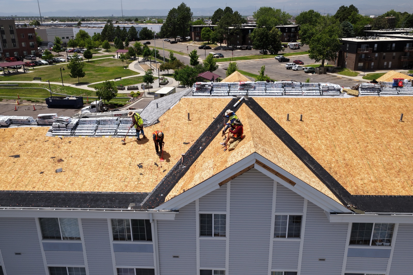
Our June 2026 Denver project — underlayment going down section by section, the dated stage documentation that supports pay apps, warranties, and owner updates.
NE DENVER · JUNE 2026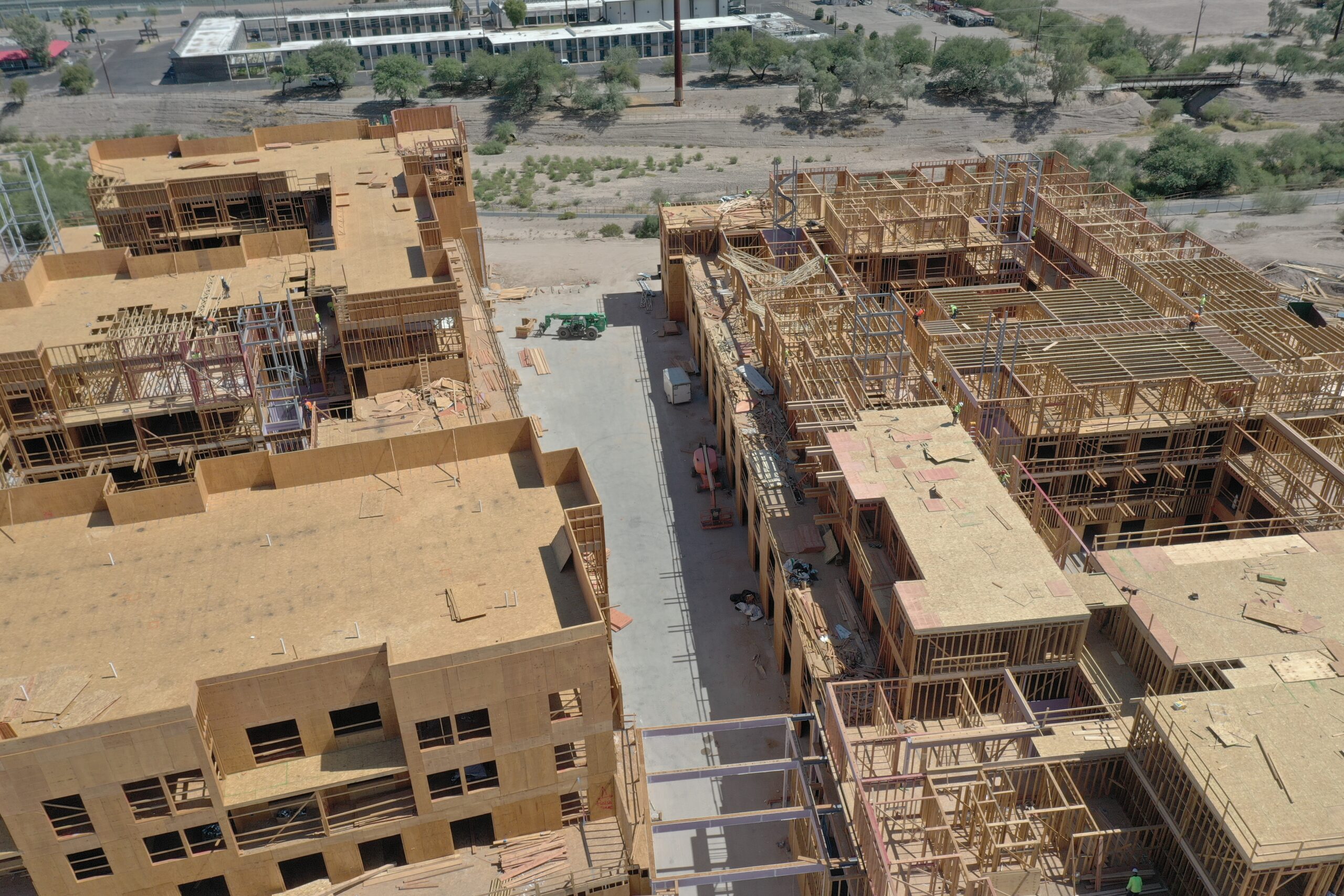
Framing, decking, and vertical progress across a multifamily site — the week-over-week record that keeps owners and lenders current.
MULTIFAMILY · FRAMING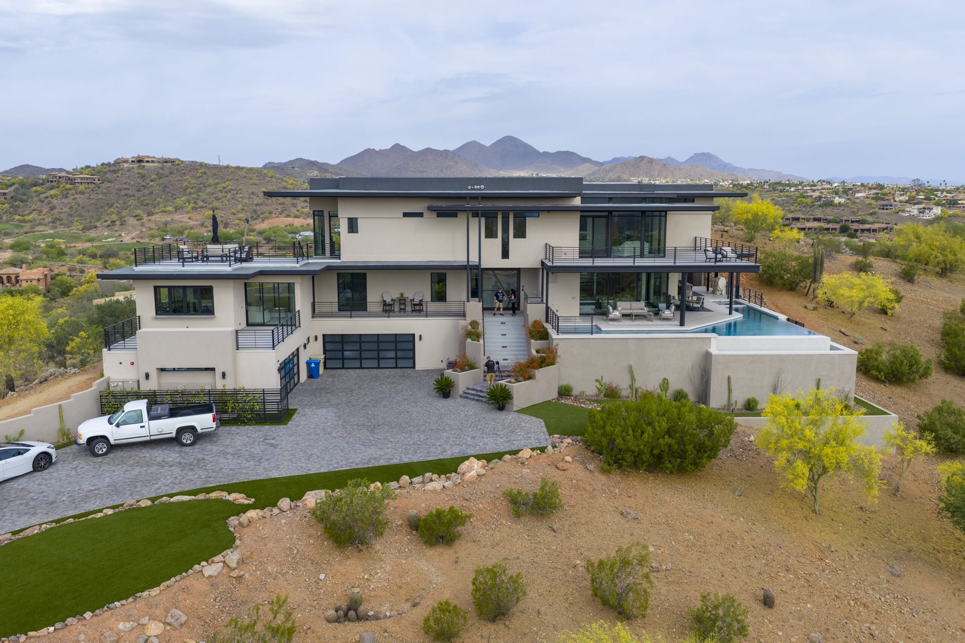
Milestone documentation on custom and luxury builds — the record the builder shares with the owner, and the marketing asset when it tops out.
CUSTOM BUILDThe Denver project above was flown by our licensed pilots on the ground in the metro, with LAANC authorization under Denver's controlled airspace. Ground-up build, exterior renovation, or master-planned community — the documentation package is the same discipline.
Set the schedule once — then the documentation just shows up.
Send the site plan and what you need documented — progress, orthos, milestones, marketing. We scope the flight plan and cadence.
Same angles every flight, LAANC pulled ahead, weather windows managed around Denver's afternoon build-ups.
Photos edited and organized by date; orthos stitched; clips cut for stakeholder updates.
Everything lands in a shared link your whole team can use, flight after flight.
Denver's building boom has specific documentation demands — we fly them.
RiNo, Five Points, and the light-rail corridors are dense, craned, and fast-moving — drone documentation keeps owners current without slowing the site.
From Castle Rock to Erie, community-scale projects need the wide view — phasing, roads, amenities, and lot progress in one frame.
Front Range afternoons bring wind and summer hail cells. We fly morning windows and build weather flex into the schedule.
DEN's Class B shelves, Centennial, Rocky Mountain Metro, and Buckley SFB cover most of the metro. We pull LAANC before every flight.
Construction documentation has to hold up — to the lender, the owner, and sometimes the courtroom. That takes a licensed, insured operation.
Construction clients often bundle these — same Denver pilots, often the same flight.
Weekly, biweekly, or milestone-based — most Denver GCs pick a cadence tied to draws and owner reporting. Same angles every flight.
Yes. Most of the metro sits under controlled airspace; we hold Part 107 certification and pull the LAANC authorization for each flight.
Yes — top-down, to-scale orthos for laydown planning and as-built comparison, exported for your team's tools.
Yes — most recently a full multifamily exterior re-roof in northeast Denver in June 2026: two days of tear-off, deck, underlayment, and completion documentation for a Colorado contractor.
We plan Denver flights around morning weather windows and build flex days into the schedule — documentation cadence survives the weather.
FAA Part 107 certified and insured with $2M liability coverage — certificate of insurance available for your GC file.
Rated 5.0★ from 271 verified Google reviews across our locations.
John and team are the consummate professionals! Very reliable, quick, and high quality deliverables!
Professional, efficient, and easy to work with. The team delivered clean, high-quality aerials and communicated clearly throughout the project.
Needed work done quickly for drone photography. They responded quickly, knew exactly what was required, and explained it well — great customer service.
John was a professional and very knowledgeable. He made the process of getting drone footage seamless and did an exceptional job.
Absolutely amazing experience with Desert Drones. They did a shoot for my business and made my product really speak for itself!
John is a true professional. Every time we need drone photography or videography done, he is excited to take on the project.
Send the site and what you need — progress, orthos, milestones — and we'll quote a cadence your project team can build around.