
Late April in southern Arizona means one thing for project managers planning Tucson construction drone photography: the clock is ticking on the dry, predictable flying weather we’ve had since November. Once monsoon season rolls in around late June, every flight becomes a calendar gamble against gust fronts, dust walls, and the surprise 3 PM thunderhead that wasn’t on the morning forecast.
If you’re running a job site in Tucson or anywhere across the Phoenix metro, this is the window to lock in a clean baseline before the chaos starts. A solid pre-monsoon flight gives your lender, your owner, and your team a reference point that holds up for the rest of the season — even when storm days knock out the next visit.
We’ve spent the last five-plus seasons flying construction sites across southern Arizona, and the pattern is the same every year. The crews who plan their April and May flights carefully don’t sweat monsoon. The ones who wait end up scrambling.
Why The Pre-Monsoon Window Matters For Tucson Construction Drone Photography
Arizona’s monsoon doesn’t care about your draw schedule. From late June through mid-September, the same conditions that build those wall clouds out near the Catalinas — heat, moisture, instability — are the ones that ground drones. FAA Part 107 rules require visual line of sight, daylight ops without a waiver, and conditions safe enough to operate. A microburst rolling off the Rincons can drop visibility to nothing in ten minutes.
What that means in practice: between roughly June 20 and September 15, you’ll lose flying days. Some weeks you’ll lose three. The work site won’t pause — concrete keeps pouring, steel keeps going up — but your visual record can stall out if you don’t have a system.
A pre-monsoon baseline solves this. We fly your site in late April or May using repeatable flight paths, capture a full set of stills, video, and an orthomosaic if you want it, and then every monsoon-window flight after that becomes a comparison point. Even if a storm cancels the July 15 visit, the August 1 flight still maps cleanly back to your baseline. Your reports stay on track.
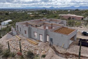
What A Pre-Monsoon Baseline Flight Should Capture
Builders we work with across the Phoenix corridor and southern Arizona usually want the same five things in a baseline package. If you’re putting one together, here’s what to ask for.
A Full-Site Orthomosaic
This is the stitched-together top-down map of your entire site, geotagged, accurate to a few centimeters. It’s the document your lender, your engineer, and your superintendent can all share and measure against. Once you have one, every subsequent flight gives you an apples-to-apples overlay.
Repeatable Flight Paths
The whole point of progress documentation is that month two looks like month one looks like month three — same altitude, same headings, same waypoints. We program the flight once and reuse it. That’s how you get a clean side-by-side at a draw meeting without arguing about which angle was which.
Cardinal-Direction Obliques
Four obliques — north, south, east, west — at a consistent altitude give you a quick visual snapshot anyone can read in two seconds. Useful for owner updates, marketing, and the kind of progress slides that go up at board meetings.
A Cinematic Pass For Marketing
While we’re already on site, a separate cinematic flight gets you usable footage for social, owner videos, and project sizzle reels later in the build. It’s a small add-on at the baseline visit and saves a return trip in August when the weather might not cooperate.
Thermal Pass If You Have Roof Or Solar Components
For sites with roofing, MEP-on-roof, or solar arrays going up, a thermal pass at the baseline gives you a heat signature you can compare later. If something starts behaving differently three months in, you have the original reference frame. Our thermal and orthomosaic capability for construction documentation is built into the same flight, so it’s not a separate visit.
Tucson vs Phoenix: Local Differences That Affect Your Flight Calendar
Even though we’re talking about one monsoon system, Tucson and the Phoenix metro behave differently enough that your schedule should reflect it.
Tucson Sites
Storms here tend to build off the Catalinas, Rincons, and Santa Ritas in the afternoon. Morning windows — generally 6 AM to 10 AM from late June through September — give you the best odds. Sites in Oro Valley, Marana, Vail, and Sahuarita all see the same pattern, with slight variations depending on which range is closest. We fly out of Tucson, so weather calls in the morning are easy for us to make in real time.
Phoenix Metro Sites
Phoenix-area storms tend to roll in later in the afternoon and from the south or southeast — coming up off the Sonoran Desert basin and hitting Chandler, Gilbert, Queen Creek, and Mesa first. The dust component is bigger out here too. A haboob can shut a site down for hours and leave a film of dust on every horizontal surface. We schedule Phoenix metro drone work early-morning where we can during monsoon weeks, and we watch the National Weather Service Phoenix discussion the night before every flight.
What To Confirm Before The Pre-Monsoon Flight
A few quick things to lock down with your drone provider before they show up.
Airspace first. If your site is anywhere near Tucson International, Davis-Monthan, Sky Harbor, Deer Valley, Falcon Field, or any of the smaller class-C and class-D fields, the pilot needs LAANC approval before the flight. We pull authorizations as a matter of course, but it’s worth checking that whoever is flying actually has the credential.
Insurance is next. Most general contractors require a current COI listing the GC as additional insured. We carry $2,000,000 in liability and can issue a COI in a day.
Site access matters more than people think. A 15-minute walkthrough on the first visit so the pilot knows where the trades are working, where the lift is parked tomorrow, and where the lay-down yard is. This makes flight planning safer and keeps the drone away from active swing zones.
Deliverable format saves headaches later. Decide upfront whether you want raw images, a curated photo set, the orthomosaic as a GeoTIFF, an annotated PDF report, or some combination. We can deliver any of these — it just helps to know before flight day so we shoot to spec.
Booking Now vs Booking In June
Here’s the practical part. Our calendar fills up fast in May because every builder in southern Arizona figures out the monsoon math at roughly the same time. If you want a baseline flight on the books before the first storms, late April and early May are the right times to lock in dates.
We’ve been doing this for five-plus years across Tucson, Phoenix, Flagstaff, Sedona, and beyond, and we’re a two-time Arizona Daily Star Readers’ Choice winner for Best Aerial Photographer (2023 and 2024). The bigger point: we’ve seen exactly which weeks vanish first on the schedule. April 28 through May 24 is the heaviest booking window of the year.
Inspection-style turnarounds on our side typically run 24 to 48 hours, so once we fly, you’ll have the deliverables in hand before your next site meeting.
Ready To Get Your Baseline Flight On The Calendar?
If you’re a GC, project owner, or lender rep with a Tucson or Phoenix-area job site running through monsoon season, this is the right week to schedule. We’ll bring the right kit, pull the LAANC, and deliver the package in the format your team will actually use. Reach out through our contact page and we’ll get a date on the calendar before May fills u