Skip to content
Logo
Facebook-f Instagram Google-plus-g Youtube Linkedin

Call Us Now

520.829.4048

  • Home
  • About
  • Services
    • Construction
    • Industrial/Mining
    • Marketing/Advertising
    • Real Estate
    • Solar
    • Roofing
    • Thermal
    • FPV Drone Videography
  • Location
    • Arizona
      • Phoenix
        • Phoenix Construction Drones
        • Industrial Drones Phoenix
        • Drone Advertising Phoenix
        • Drone Real Estate Photography Phoenix
        • Drone Roof Inspections Phoenix
        • Drone Solar Panel Inspections Phoenix
        • Drone Thermal Inspections Phoenix
        • Drone Photography Phoenix
        • Drone Videography Phoenix
        • Aerial Photography Phoenix
        • Aerial Videography Phoenix
        • FPV Drone Videography Phoenix
      • Tucson
        • Drones For Construction
        • Industrial and Mining Drones
        • Drone Advertising
        • Drone Real Estate Photography
        • Drones For Roofing
        • Drones For Solar Inspections
        • FLIR (Thermal Camera)
        • FPV Drone Videography Tucson
      • Drone Companies Arizona
      • Drone Photography Arizona
      • Drone Videography Arizona
      • Aerial Photography Arizona
      • Aerial Videography Arizona
    • Nevada
      • Las Vegas
        • Las Vegas Construction Drones
        • Industrial Drones Las Vegas
        • Drone Advertising Las Vegas
        • Drone Real Estate Photography Las Vegas
        • Drone Roof Inspections Las Vegas
        • Drone Solar Panel Inspections Las Vegas
        • Drone Thermal Inspections Las Vegas
        • FPV Drone Videography Las Vegas
    • Texas
      • Dallas
        • Construction Drone Services in Dallas & Across Texas
        • Industrial Drone Services in Dallas & Across Texas
        • Drone Advertising Dallas Texas
        • Drone Real Estate Photography Services in Dallas & Across Texas
        • Drone Roof Inspection Services in Dallas & Across Texas
        • Drone Solar Panel Inspection Services in Dallas & Across Texas
        • Thermal Drone Inspection Services in Dallas & Across Texas
        • FPV Drone Videography Dallas
      • El Paso
        • El Paso Construction Drones
        • Industrial Drones El Paso
        • Drone Advertising El Paso
        • Drone Real Estate Photography El Paso
        • Drone Roof Inspections El Paso
        • Drone Solar Panel Inspections El Paso
        • Drone Thermal Inspections El Paso
        • FPV Drone Videography El Paso
    • Colorado
      • Denver
        • Construction Drone Services in Denver & Across Colorado
        • Industrial Drone Services in Denver & Across Colorado
        • Drone Advertising Denver Colorado
        • Drone Real Estate Photography Services in Denver & Across Colorado
        • Drone Roof Inspection Services in Denver & Colorado | Aerial Roof Inspections
        • Drone Solar Panel Inspection Services in Denver & Colorado | Commercial Solar Inspections
        • Thermal Drone Inspection Services in Denver & Across Colorado
        • FPV Drone Videography Denver
    • New Mexico
      • Albuquerque
        • Albuquerque Construction Drones
        • Industrial Drones Albuquerque
        • Drone Advertising Albuquerque
        • Drone Real Estate Photography Albuquerque
        • Drone Roof Inspections Albuquerque
        • Drone Solar Panel Inspections Albuquerque
        • Drone Thermal Inspections Albuquerque
        • FPV Drone Videography Albuquerque
  • Contact
  • Gallery
  • Pilot for Us
  • Blog
    • Construction
    • Real Estate
    • Inspection
    • Videography & Marketing
    • Aerial Photography
  • FAQs
Logo

Call Us Now

520.829.4048

  • Home
  • About
  • Services
    • Construction
    • Industrial/Mining
    • Marketing/Advertising
    • Real Estate
    • Solar
    • Roofing
    • Thermal
    • FPV Drone Videography
  • Location
    • Arizona
      • Phoenix
        • Phoenix Construction Drones
        • Industrial Drones Phoenix
        • Drone Advertising Phoenix
        • Drone Real Estate Photography Phoenix
        • Drone Roof Inspections Phoenix
        • Drone Solar Panel Inspections Phoenix
        • Drone Thermal Inspections Phoenix
        • Drone Photography Phoenix
        • Drone Videography Phoenix
        • Aerial Photography Phoenix
        • Aerial Videography Phoenix
        • FPV Drone Videography Phoenix
      • Tucson
        • Drones For Construction
        • Industrial and Mining Drones
        • Drone Advertising
        • Drone Real Estate Photography
        • Drones For Roofing
        • Drones For Solar Inspections
        • FLIR (Thermal Camera)
        • FPV Drone Videography Tucson
      • Drone Companies Arizona
      • Drone Photography Arizona
      • Drone Videography Arizona
      • Aerial Photography Arizona
      • Aerial Videography Arizona
    • Nevada
      • Las Vegas
        • Las Vegas Construction Drones
        • Industrial Drones Las Vegas
        • Drone Advertising Las Vegas
        • Drone Real Estate Photography Las Vegas
        • Drone Roof Inspections Las Vegas
        • Drone Solar Panel Inspections Las Vegas
        • Drone Thermal Inspections Las Vegas
        • FPV Drone Videography Las Vegas
    • Texas
      • Dallas
        • Construction Drone Services in Dallas & Across Texas
        • Industrial Drone Services in Dallas & Across Texas
        • Drone Advertising Dallas Texas
        • Drone Real Estate Photography Services in Dallas & Across Texas
        • Drone Roof Inspection Services in Dallas & Across Texas
        • Drone Solar Panel Inspection Services in Dallas & Across Texas
        • Thermal Drone Inspection Services in Dallas & Across Texas
        • FPV Drone Videography Dallas
      • El Paso
        • El Paso Construction Drones
        • Industrial Drones El Paso
        • Drone Advertising El Paso
        • Drone Real Estate Photography El Paso
        • Drone Roof Inspections El Paso
        • Drone Solar Panel Inspections El Paso
        • Drone Thermal Inspections El Paso
        • FPV Drone Videography El Paso
    • Colorado
      • Denver
        • Construction Drone Services in Denver & Across Colorado
        • Industrial Drone Services in Denver & Across Colorado
        • Drone Advertising Denver Colorado
        • Drone Real Estate Photography Services in Denver & Across Colorado
        • Drone Roof Inspection Services in Denver & Colorado | Aerial Roof Inspections
        • Drone Solar Panel Inspection Services in Denver & Colorado | Commercial Solar Inspections
        • Thermal Drone Inspection Services in Denver & Across Colorado
        • FPV Drone Videography Denver
    • New Mexico
      • Albuquerque
        • Albuquerque Construction Drones
        • Industrial Drones Albuquerque
        • Drone Advertising Albuquerque
        • Drone Real Estate Photography Albuquerque
        • Drone Roof Inspections Albuquerque
        • Drone Solar Panel Inspections Albuquerque
        • Drone Thermal Inspections Albuquerque
        • FPV Drone Videography Albuquerque
  • Contact
  • Gallery
  • Pilot for Us
  • Blog
    • Construction
    • Real Estate
    • Inspection
    • Videography & Marketing
    • Aerial Photography
  • FAQs
  • Home
  • About
  • Services
    • Construction
    • Industrial/Mining
    • Marketing/Advertising
    • Real Estate
    • Solar
    • Roofing
    • Thermal
    • FPV Drone Videography
  • Location
    • Arizona
      • Phoenix
        • Phoenix Construction Drones
        • Industrial Drones Phoenix
        • Drone Advertising Phoenix
        • Drone Real Estate Photography Phoenix
        • Drone Roof Inspections Phoenix
        • Drone Solar Panel Inspections Phoenix
        • Drone Thermal Inspections Phoenix
        • Drone Photography Phoenix
        • Drone Videography Phoenix
        • Aerial Photography Phoenix
        • Aerial Videography Phoenix
        • FPV Drone Videography Phoenix
      • Tucson
        • Drones For Construction
        • Industrial and Mining Drones
        • Drone Advertising
        • Drone Real Estate Photography
        • Drones For Roofing
        • Drones For Solar Inspections
        • FLIR (Thermal Camera)
        • FPV Drone Videography Tucson
      • Drone Companies Arizona
      • Drone Photography Arizona
      • Drone Videography Arizona
      • Aerial Photography Arizona
      • Aerial Videography Arizona
    • Nevada
      • Las Vegas
        • Las Vegas Construction Drones
        • Industrial Drones Las Vegas
        • Drone Advertising Las Vegas
        • Drone Real Estate Photography Las Vegas
        • Drone Roof Inspections Las Vegas
        • Drone Solar Panel Inspections Las Vegas
        • Drone Thermal Inspections Las Vegas
        • FPV Drone Videography Las Vegas
    • Texas
      • Dallas
        • Construction Drone Services in Dallas & Across Texas
        • Industrial Drone Services in Dallas & Across Texas
        • Drone Advertising Dallas Texas
        • Drone Real Estate Photography Services in Dallas & Across Texas
        • Drone Roof Inspection Services in Dallas & Across Texas
        • Drone Solar Panel Inspection Services in Dallas & Across Texas
        • Thermal Drone Inspection Services in Dallas & Across Texas
        • FPV Drone Videography Dallas
      • El Paso
        • El Paso Construction Drones
        • Industrial Drones El Paso
        • Drone Advertising El Paso
        • Drone Real Estate Photography El Paso
        • Drone Roof Inspections El Paso
        • Drone Solar Panel Inspections El Paso
        • Drone Thermal Inspections El Paso
        • FPV Drone Videography El Paso
    • Colorado
      • Denver
        • Construction Drone Services in Denver & Across Colorado
        • Industrial Drone Services in Denver & Across Colorado
        • Drone Advertising Denver Colorado
        • Drone Real Estate Photography Services in Denver & Across Colorado
        • Drone Roof Inspection Services in Denver & Colorado | Aerial Roof Inspections
        • Drone Solar Panel Inspection Services in Denver & Colorado | Commercial Solar Inspections
        • Thermal Drone Inspection Services in Denver & Across Colorado
        • FPV Drone Videography Denver
    • New Mexico
      • Albuquerque
        • Albuquerque Construction Drones
        • Industrial Drones Albuquerque
        • Drone Advertising Albuquerque
        • Drone Real Estate Photography Albuquerque
        • Drone Roof Inspections Albuquerque
        • Drone Solar Panel Inspections Albuquerque
        • Drone Thermal Inspections Albuquerque
        • FPV Drone Videography Albuquerque
  • Contact
  • Gallery
  • Pilot for Us
  • Blog
    • Construction
    • Real Estate
    • Inspection
    • Videography & Marketing
    • Aerial Photography
  • FAQs

Drone Surveying: Understanding the Difference Between Aerial Photography and Photogrammetry

Drone Surveying: Understanding the Difference Between Aerial Photography and Photogrammetry

Roof Orthomosaic
Roof Orthomosaic

Drone Surveying: Understanding the Difference Between Aerial Photography and Photogrammetry

Why Photogrammetry is Essential for Surveying Projects

Even beginners in drone usage know that drones are widely used for taking photographs. This accessibility has popularized drone aerial photography across various sectors, resulting in some stunning images. However, is it suitable for mapping or surveying tasks? The reality is that simple aerial photographs are insufficient for providing the perspective-free, measurable digital images required for surveying. For such precision, photogrammetry is necessary.

What is Aerial Photography?

Aerial photography involves capturing photographic images from an airborne device. This can include drones, planes, or helicopters. According to the United States Geological Survey, aerial photography is a common form of remote sensing, which is the measurement of an area’s characteristics from a distance. While photographic images are user-friendly and have applications in multiple industries, they are not very accurate for surveying without being integrated into a photogrammetric model.

Types of Aerial Photography

Aerial photography can be categorized into vertical and oblique types.
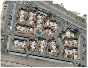
  • Vertical Photography: These images are taken directly above the target, minimizing perspective issues and allowing for easy comparison of photos from different areas taken at the same height. Vertical aerial photographs are ideal for large-scale mapping and can be taken from higher altitudes, offering consistency across different geographical areas.
  • Oblique Photography: Taken at an angle (often around 45 degrees), these images are usually captured from lower elevations and are useful for uniquely shaped features but are less suitable for large surveying projects. Oblique photographs provide a different perspective that can be more visually informative for specific features but lack the scalability of vertical photographs.

Aerial Photography vs. Satellite Imagery

Aerial photography differs from satellite imagery. Aerial photos can be taken from various airborne devices at any altitude, while satellite images are captured by devices orbiting the earth. Satellite imagery is more commonly used in scientific research and weather monitoring, whereas aerial photography is widely used for smaller, more detailed projects.

Limitations of Aerial Photography

While aerial photography is valuable for creating visual representations, it lacks the accuracy needed for precise measurements and surveying. Vertical photographs can still have displaced or distorted coordinates and fail to provide reliable topographical information. Therefore, aerial photographs alone are inadequate for tasks that require specific measurements.

What is Aerial Photogrammetry?

Photogrammetry involves taking multiple images from different angles to create high-resolution 2D or 3D digital models that allow for accurate measurements. This technique, developed over 150 years ago, has become more accessible with advancements in digital imaging and drone technology. Photogrammetry uses the concept of triangulation to determine the location of points in three-dimensional space. By capturing images from multiple perspectives, software can calculate the exact position and dimensions of objects, creating a detailed map or model.

Types of Aerial Photogrammetry

  • Metric Photogrammetry: Uses coordinate points to create precise visualizations with accurate measurements. This type of photogrammetry is essential for applications that require exact dimensions, such as engineering and construction.
  • Interpretive Photogrammetry: Adds topography using indicators like shapes, shadows, and patterns rather than exact coordinates. While less precise, interpretive photogrammetry can be useful for applications where detailed measurements are not as critical, such as environmental studies or historical site documentation.

Uses of Aerial Photogrammetry

Photogrammetry is essential for various industries, including:
  • Engineering: Creating 3D models of buildings and equipment, enabling precise planning and analysis.
  • Construction: Surveying land and revealing important information for building projects, ensuring accurate site preparation and project execution.
  • Land Surveying: Understanding the topography of an area, crucial for urban planning, agriculture, and resource management.
  • Real Estate: Producing accurate 3D models of properties for virtual tours, especially popular during the COVID-19 pandemic, enhancing the buying and selling process by providing potential buyers with detailed, immersive views of properties.

Photogrammetry vs. LiDAR

While both techniques create accurate 3D models, they differ in approach. Photogrammetry uses photographic images to identify coordinates, while LiDAR (Light Detection and Ranging) measures the time a light wave takes to reflect back to the drone. LiDAR is more precise but also more expensive and requires bulkier equipment.
  • Photogrammetry: Ideal for projects where high-resolution images and visual detail are essential. It is cost-effective and suitable for a wide range of applications.
  • LiDAR: Best for projects requiring extreme accuracy, such as those involving complex terrain or dense vegetation. LiDAR can penetrate foliage, making it useful for forestry, archaeology, and other applications where ground visibility is limited.

Ground Sample Distance in Aerial Photography and Photogrammetry

Ground Sample Distance (GSD) is crucial for scaling aerial photographs and photogrammetry models. It refers to the real distance between the centers of two consecutive pixels in an image. The required GSD depends on the scope of the surveying project, with larger-scale projects needing higher GSD and smaller, detailed projects requiring lower GSD. To calculate GSD, you need to consider your drone’s sensor height and width, image height and width, focal length, and flight height. Accurate GSD ensures that the photogrammetry model is scaled correctly, providing reliable measurements.

Supporting Aerial Photogrammetry with Drones

Drones are invaluable for photogrammetry, offering a cost-effective and time-saving alternative to traditional surveying techniques. For effective photogrammetry, drones need to capture high-quality aerial photographs. Advanced drones like the Matrice 300 RTK, equipped with DJI Terra mapping software, streamline the process of stitching images together and creating accurate 2D and 3D maps. Using drones for photogrammetry allows surveyors to cover large areas quickly and safely, avoiding hazardous locations while collecting comprehensive data. This approach enhances efficiency, reduces costs, and provides detailed insights that traditional methods cannot match.

Conclusion

While aerial photography has transformed scientific research and mapping, photogrammetry is necessary for precise surveying. It allows for the creation of accurate 2D and 3D models with detailed coordinates, making it indispensable for modern surveyors. With the right drones and software, no mapping or surveying job is too challenging. By integrating photogrammetry into your surveying toolkit, you can achieve higher accuracy, better data quality, and improved project outcomes. Embracing this advanced technology ensures that you stay at the forefront of the industry, delivering exceptional results for your clients.

Recent Posts

Recent Posts
  • Drone Real Estate Photography in Arizona: Why Aerial Imagery Sells Homes Faster
  • Drone Roof Inspections in Arizona: Faster, Safer, and More Accurate Solutions
  • How Drone Photography Gives Arizona Businesses a Marketing Edge
  • Drone Surveys for Accessory Dwelling Unit Construction
  • Using Drones for Data Cabling Inspection

Tucson Address

  • 5325 N Gerhart Rd
    Tucson, AZ 85745
  • 520-829-4048
  • john@desertdronesllc.com

Phoenix Addresses

  • 2550 W Union Hills Dr Suite 350
    Phoenix, AZ 85027
  • 480.845.0274
  • john@desertdronesllc.com
  • 3707 E Southern Ave
    Phoenix, AZ 85206
  • 480.582.9117
  • john@desertdronesllc.com

Albuquerque Address

  • 500 Marquette Ave NE
    Albuquerque, NM 87108
  • 505.257.6222
  • john@desertdronesllc.com

Las Vegas Address

  • 2300 W Sahara Ave
    Las Vegas, NV 89102
  • 702.707.7066
  • john@desertdronesllc.com

El Paso Address

  • 500 N Oregon St
    El Paso, TX 79901
  • 915.237.1040
  • john@desertdronesllc.com

Denver Address

  • 1801 Wewatta St
    Denver, CO 80202
  • 303.997.3271
  • john@desertdronesllc.com

Dallas Address

  • 18383 Preston Rd
    Dallas, TX 75252
  • 469.949.1776
  • john@desertdronesllc.com

About

  • Home
  • About
  • Construction
  • Industrial/Mining
  • Marketing/Advertising
  • Real Estate
  • Roofing
  • Solar
  • Thermal
  • Contact
  • Gallery
  • Locations
  • Events
  • FAQ

Follow

Facebook-f Instagram Google-plus-g Youtube
Logo
Desert Drones LLC © 2026
520-829-4048