
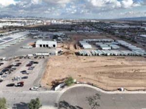
The Phoenix metro is one of the most active construction markets in the country right now, and it doesn’t show any signs of slowing down.
The West Valley is in the middle of a massive residential buildout. Buckeye, Goodyear, and Surprise are adding thousands of homes a year. The Loop 303 corridor in the northwest is lined with distribution centers and industrial projects. Chandler’s semiconductor corridor is hosting some of the largest manufacturing investments in American history. And downtown Phoenix, Tempe, and Scottsdale are all seeing high-rise and mixed-use development at a pace that would have seemed impossible ten years ago.
All of that construction needs documentation. Desert Drones LLC provides FAA-certified aerial photography and videography for construction projects across the Phoenix metro, giving homebuilders, commercial developers, general contractors, and project owners a fast, professional aerial record of every phase of their projects.
Why Aerial Documentation Matters on Phoenix Construction Projects
A construction project without aerial documentation is flying blind. Site conditions change fast, and the ground-level view captures only a fraction of what’s actually happening on a job site at any given time.
From the air, you see everything. Site layout and grading progress. Structural framing at scale. Utility and infrastructure work that’s about to be buried. Landscaping and hardscaping as it comes together. The relationship between buildings, parking, access points, and surrounding context. All of it in a single shot that tells a story no ground photo can.
For homebuilders, aerial progress photography creates marketing content that sells lots and homes before they’re finished. For commercial developers, it produces the project imagery lenders, investors, and future tenants need to see. For general contractors, it creates a documented third-party record that protects everyone when questions come up about site conditions or work sequence.
And in a market as competitive as Phoenix, projects that show up with professional aerial documentation simply look more serious than ones that don’t.
Residential Construction in the West Valley
The West Valley is where Phoenix’s residential construction story is being written right now. Buckeye is one of the fastest growing cities in the country. Goodyear’s Estrella Mountain Ranch and Palm Valley corridors are filling in fast. Surprise’s Prasada community and the areas around Bell Road and the 303 are adding new subdivisions every quarter.
For production homebuilders active in these markets, aerial progress photography serves multiple purposes at once. Monthly or bi-monthly aerial shots document community buildout for investor and lender reporting. Progress imagery of model homes and amenity construction feeds the marketing pipeline before the product is even finished. And community aerials showing completed homes, landscaping, and neighborhood infrastructure are some of the most effective marketing tools available for master-planned community sales.
We work with production builders on scheduled progress packages, flying the same routes at the same angles on a consistent schedule so every update is directly comparable to the last. You end up with a visual timeline of the project that’s genuinely useful for internal reporting, external marketing, and long-term project records.
Commercial and Industrial Construction
Phoenix’s commercial construction market is diversified across several high-growth sectors, and we work across all of them.
The distribution and logistics corridor along I-10 West from Goodyear through Avondale has become one of the most active industrial construction zones in the Southwest. Warehouses in the 500,000 to 2 million square foot range are going up along this corridor regularly, and aerial documentation of these projects serves leasing, investment, and owner reporting needs throughout construction.
In Chandler, the semiconductor manufacturing buildout around the Intel Ocotillo Campus and TSMC’s Arizona Fab 21 has created demand for construction documentation of some of the most technically complex industrial projects in the country. These facilities require detailed aerial progress records for owner reporting, contractor coordination, and public affairs purposes.
Medical and healthcare construction is another active sector across the metro. Banner Health, Dignity Health, and HonorHealth are all expanding their footprints in Phoenix, Gilbert, and the northwest Valley. Aerial progress documentation of healthcare construction serves the same owner reporting and marketing purposes as other commercial sectors, with the added dimension that these projects often have community relations components that benefit from professional imagery.
Downtown Phoenix, Tempe, and Scottsdale Development
The urban cores of the Phoenix metro are seeing a different kind of construction story. Downtown Phoenix’s Warehouse District and Roosevelt Row are in the middle of a mid-rise and high-rise development cycle. Tempe’s waterfront along Tempe Town Lake continues to add residential towers and mixed-use projects. Old Town Scottsdale and the Scottsdale Road corridor are seeing boutique hotel and luxury residential development.
Urban construction aerial photography is technically more demanding than suburban site work. Sky Harbor International Airport’s airspace covers a large swath of central Phoenix, requiring LAANC authorization for every flight. Downtown towers create rotor wash and turbulence considerations. And the density of the urban environment means every shot has to be carefully composed to show the project without misrepresenting surrounding context.
We’ve flown urban Phoenix aerial photography extensively and understand the airspace and operational environment. We handle LAANC authorization before every flight and communicate the airspace timeline with you upfront so there are no scheduling surprises.
What We Document and When
The most useful construction aerial documentation happens at key project milestones rather than on a fixed calendar schedule. The milestones that matter most vary by project type, but typically include site clearing and grading completion, foundation work, structural framing at various stages, exterior skin and roof completion, MEP rough-in for large commercial projects, landscaping and hardscaping, and final completion.
For projects with a marketing component, we also schedule targeted shoots around model home completions, amenity openings, and other sales milestones where aerial imagery will directly feed into marketing campaigns.
For ongoing construction with regular lender or investor reporting requirements, we set up a fixed monthly or weekly schedule so aerial updates arrive on a predictable cadence. These scheduled packages include consistent flight paths and camera angles so progress is visually comparable from update to update.
Deliverables and Turnaround
Every construction shoot delivers 4K video edited and color-graded for immediate use, high-resolution still photography at multiple altitudes and angles, and digital delivery within 24 to 48 hours of the flight. Files are formatted for immediate use in marketing materials, presentations, investor reports, and social media.
For projects with regular progress documentation needs, we deliver consistent file naming and organization so your internal team can manage the archive easily over the life of the project.
We also offer expedited same-day delivery for time-sensitive project needs — lender site visits, investor presentations, or last-minute marketing requests. Call us if you need it fast.
FAA Compliance Across the Phoenix Metro
Commercial drone photography in the Phoenix metro requires navigating one of the more complex airspace environments in the Southwest. Sky Harbor International Airport’s Class B airspace covers a large area of central Phoenix. Luke Air Force Base in Glendale has its own airspace structure that extends across significant portions of the West Valley. Scottsdale Airport, Phoenix Deer Valley Airport, and Mesa Gateway Airport all have controlled airspace that affects operations in their respective areas.
All of our Phoenix flights are conducted under FAA Part 107 certification with LAANC airspace authorization where required. We’ve mapped the Phoenix airspace environment extensively and know exactly what’s required for every part of the metro. You don’t have to think about compliance — we handle it, document it, and keep authorization records on file for every project.
Ready to Document Your Phoenix Project?
Whether you’re building production homes in Buckeye, a distribution center off the I-10, a medical campus in Gilbert, or a mixed-use tower in downtown Tempe, Desert Drones LLC delivers professional aerial construction documentation that makes your project look as serious as it is.
Get a Quote for Phoenix Construction Photography
Call or book online. We’ll set up a documentation schedule that fits your project timeline, and you’ll have the first deliverables in hand within 48 hours of the first flight.
Frequently Asked Questions
How often should I schedule aerial photography for a Phoenix construction project?
For active residential communities and commercial projects with lender or investor reporting, monthly is the most common cadence. Projects with aggressive timelines or high marketing demand often go bi-weekly. We will work with your reporting schedule to set a cadence that makes sense for your project.
Can you fly near Sky Harbor Airport for Phoenix construction shoots?
Yes. Sky Harbor’s Class B airspace covers a large portion of central Phoenix and requires LAANC authorization, which we file before every flight. We know the Phoenix airspace environment well and factor authorization lead time into scheduling upfront — no day-of surprises.
What format do you deliver Phoenix construction progress photos in?
We deliver 4K color-graded video and high-resolution still photos in both full-resolution TIFF and web-optimized JPEG. Files are labeled and organized for easy integration into your marketing, lender reports, and internal project records.
Do you cover Goodyear, Surprise, Buckeye, and the West Valley?
Yes. The West Valley is one of our most active construction markets. We cover the full Phoenix metro including Goodyear, Surprise, Buckeye, Avondale, Peoria, and Glendale. We also handle Luke AFB airspace coordination for projects in the northwest Valley.