
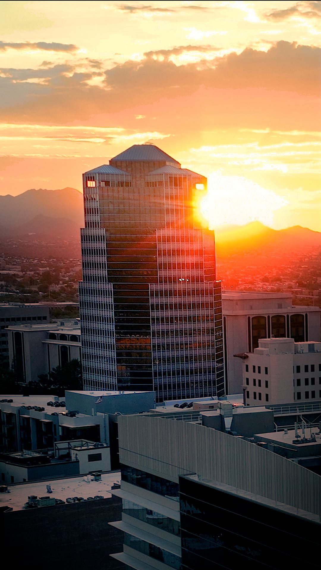
Tucson Aerial Photography in Monsoon Season — The Best Light of the Year
When the monsoon breaks over Tucson in July, the Sonoran Desert transforms. The air clears. The Catalina Mountains turn purple-blue. Desert washes that have been bone-dry for months suddenly flow with water, and the entire landscape shifts into sharp, dramatic relief. If you’ve ever tried to shoot aerial photography in Tucson during the hot, hazy months of May and June, you know how flat the light can feel. But post-monsoon? That’s when the Sonoran truly shines.
Desert Drones LLC provides aerial drone services across Tucson year-round — real estate, construction, solar inspection, roofing, and commercial video covering all of Southern Arizona.
For the construction site manager, the real estate agent showing mid-century homes in the foothills, or the solar company documenting installations across southern Arizona, this window — roughly 45 minutes after a storm clears — is pure gold. The light is clean. The shadows are defined. The entire city photographs like it was designed for the camera. And here’s the thing: you don’t have to travel to San Francisco or New York to get that kind of quality. You’re already here. You’re already in Tucson.
That’s exactly why Desert Drones LLC loves working here in July. We know Tucson’s geography, its neighborhoods, and the precise timing that makes drone photography sing. Whether you need construction progress documentation, real estate aerial shots, or thermal inspections on commercial properties, monsoon season is when we deliver our best work.
Why Tucson in July Is Unique for Aerial Photography
Post-Monsoon Light and the 45-Minute Golden Window
Monsoon season in Tucson isn’t a single downpour. It’s a pattern: humid buildup, afternoon thunderstorms that roll in fast, and then — a break. The clouds clear. The sun hits wet surfaces. Dust settles. For roughly 45 minutes after a major storm system passes, the visibility is exceptional and the light has a quality you won’t find on clear June afternoons. The air isn’t just clear; it’s crisp. Colors pop. Shadows have depth. This is why professional aerial photographers schedule shoots around the monsoon calendar, not despite it.
The Catalina Mountains, normally hazy in the distance, become defined wall of rock. The bajada (that gradual slope from the mountains to the valley floor) shows its topology. Even asphalt and concrete look better — textures appear, drainage patterns become visible, and construction sites look properly finished and detailed. Real estate photographers who understand the monsoon schedule don’t fight the heat of 115°F afternoons; they plan for 6:30 or 7:00 AM shoots on the tail end of overnight cloud cover, when the air is stillest and the light is coming in low and clean.
- Post-storm visibility increases 30–40% compared to early morning clear-sky conditions
- Wet surfaces (concrete, asphalt, roofing) photograph with more texture and detail
- Shadow definition helps show topography, building contours, and site layout
- The Catalinas, Rincons, and Santa Ritas photograph in full color rather than haze
- Early morning temperatures (80–85°F) allow equipment to operate at peak performance
Water, Geology, and the Transformed Desert Landscape
One of the most visually striking aspects of Tucson’s monsoon season is what happens to the hydrology. Normally ephemeral washes — Rillito, Pantano, Sabino Creek — run dry for months. Then the storms come. Suddenly there’s water flowing, green vegetation shows up along banks, and the entire visual character of those corridors changes. If you’re documenting a property near any of these water features, July is the moment to capture them at their most dramatic.
The geology also becomes more apparent. The Santa Catalina Mountains, especially the granite peaks north of Tucson, photograph in sharp relief. The Saguaro National Park East (in the Rincon Mountains) becomes a textured landscape of columnar cactus and palo verde trees. Commercial properties in the foothills or along the bajada show their relationship to the land more clearly. Roof lines stand out. Parking lots photograph with crisp definition. For thermal inspections and structural assessments, this clarity is invaluable.
- Desert washes fill with water, creating linear features visible from altitude
- Vegetation response to monsoon moisture makes green corridors visible
- Mountain slopes and ridgelines photograph with sharp, defined shadows
- Rock formations and bajada texture become visually prominent
- Entire neighborhoods in the foothills (Catalina Foothills, Sabino Canyon area) photograph with depth and dimension
The Urban Mosaic: Neighborhoods and Landmarks
Tucson sprawls across multiple distinct neighborhoods and districts, each with its own character. In July, when the air clears and the light improves, these neighborhoods become compelling subjects for aerial real estate coverage. The Catalina Foothills, with their mid-century homes and Saguaro-dotted lots, photograph beautifully in post-storm light. Downtown Tucson — the Congress Street corridor, the University of Arizona campus, and the historic neighborhoods to the south — shows its urban texture. The Westside, where much of Tucson’s commercial and industrial development is concentrated, benefits enormously from clear aerial visibility.
Landmarks like the Arizona-Sonora Desert Museum, Sabino Canyon, and the Mission San Xavier del Bac are iconic views, but they’re even more striking from altitude in July. If you’re marketing a property or documenting construction progress anywhere in these areas, the post-monsoon window gives you the best visual result. Developers working on subdivisions in the Oro Valley or Marana area (north of Tucson) will see their sites photograph with clarity and definition that simply isn’t available in May or June.
- Catalina Foothills: rolling terrain, large-lot properties, Saguaro-dense landscape
- Downtown/Congress Corridor: historic street grid, UA campus, mixed-use density
- Westside: retail corridors, industrial parks, solar installations spreading across the bajada
- Oro Valley and Marana: suburban development against mountain backdrop
- Historic neighborhoods: Barrio Viejo, Armory Park, Grant Park (south side) photograph with authentic character in clear light
What We Cover in Tucson
Construction Progress Documentation: Whether you’re managing a residential project in the Catalina Foothills or a commercial build on the Westside, we provide regular construction photography that shows every phase. Aerial perspective reveals site layout, progress relative to neighboring properties, and overall project scope. Monthly or weekly shots become a visual timeline your stakeholders understand immediately. In Tucson, we schedule these shoots early — 6:30–7:30 AM — to beat the heat and capture the clearest light.
Real Estate Aerial Photography: A home listing in the Catalina Foothills needs more than ground-level shots. Aerial real estate photography shows lot size, relationship to surrounding properties, views to mountains, and the full character of the property and neighborhood. In July, when the light is clean and the Catalinas are vivid, a good aerial shot closes deals. We work with local real estate agents and brokers throughout Tucson to deliver images that make properties stand out.
Solar Installation Documentation: Tucson is a solar powerhouse. Whether you’re documenting a rooftop installation on a commercial building or a ground-mount solar array across the bajada, we provide clear, detailed aerial shots that show system layout, installation completeness, and the property context. Solar documentation serves your warranty needs, your insurance needs, and your marketing. We capture it all.
Thermal Imaging and Inspections: Thermal imaging reveals what visible light can’t: heat loss, electrical hotspots, roof membrane issues, and water intrusion. Paired with roof inspections, thermal data helps property managers, facility owners, and contractors understand the true condition of commercial and industrial properties. We fly thermal on commercial buildings throughout Tucson, from the Westside industrial corridor to downtown mixed-use properties.
Commercial Property Inspections: Warehouses, shopping centers, office parks, and industrial facilities benefit from comprehensive aerial inspection. We document roof condition, HVAC systems, parking lot layout, and overall site integrity. For property managers and owners across Tucson, these inspections provide third-party documentation that supports maintenance decisions and insurance claims.
Orthomosaic Mapping and Surveys: Need precise orthomosaic mapping of a development site, a solar array, or an industrial property? We provide high-resolution mosaic imagery that shows accurate top-down geometry and spatial relationships. Useful for planning, engineering, and regulatory compliance.
FPV Videography and Marketing Content: For real estate marketing, promotional videos, or construction narrative content, FPV and high-end aerial videography creates dynamic, engaging footage. Flying through a neighborhood, gliding across a property, or following a construction site’s transformation — these shots tell a story that static photos can’t match.
How the Process Works
Before the Shoot
- Site Assessment and Weather Planning: We review your location, objectives, and any airspace considerations. In July, we monitor monsoon forecasts closely — an ideal shoot window is often 24–48 hours after a storm system passes. We communicate timing to you and adjust schedules as weather evolves.
- Client Brief: What do you need? Are you focusing on construction progress, property features, or system documentation? Are there specific landmarks or angles that matter? We align expectations and discuss how the final images will be used.
- Equipment Check: All aircraft, sensors, batteries, and backup systems are inspected. July heat requires extra diligence — we manage battery performance, ensure thermal camera calibration, and verify all systems for optimal performance in Tucson conditions.
- Airspace Clearance: We confirm FAA Part 107 compliance, check for TFRs (temporary flight restrictions), and ensure we have proper authorization for your location. Tucson airspace includes proximity to Davis-Monthan AFB, so we take these considerations seriously.
- Shot List and Storyboarding: We provide you with a preliminary shot list: angles, altitudes, coverage areas, and estimated footage. For real estate or marketing work, this becomes the blueprint for the day.
On the Day of the Shoot
- Early Arrival: We arrive 30–45 minutes before the scheduled shoot window. This gives us time to set up, conduct final equipment checks, and confirm site access and any last-minute details.
- Flight Operations: Once conditions are green, we launch the aircraft and begin capturing imagery according to the shot list. For construction or real estate, this typically involves multiple altitudes (50 feet to 300+ feet), various angles, and both wide context shots and detailed close-ups.
- Real-Time Communication: You or your site representative can observe the flight and provide real-time feedback. We adjust angles, altitudes, or coverage as needed to ensure we’re capturing exactly what you need.
- Data Management: All footage is recorded on redundant storage. We verify file integrity on-site and provide you with immediate assurance that the shoot was successful.
- Site Documentation: We photograph conditions, note any weather changes, and document the overall context of the shoot for your records.
After the Shoot
- Post-Processing: Raw footage is imported into professional editing software. We apply color correction, stabilization (for video), and quality enhancement. For thermal imagery, we generate both raw and processed thermal maps.
- Image Selection and Curation: We review all captures and select the strongest frames. For real estate, this means 15–30 high-quality final images. For construction, it’s a comprehensive time-stamped series. For gallery-ready work, every image is polished.
- Deliverable Preparation: Images are organized, properly named, and provided in formats suitable for your use — high-resolution for print or web, optimized for real estate portals, GIS-compatible for mapping projects, or video-ready for marketing content.
- Turnaround: We typically deliver final images within 3–5 business days. For time-sensitive projects, we can expedite.
- Revision and Support: Questions about an image? Need a crop or adjustment? We’re here to ensure you’re completely satisfied with the deliverables.
Who Benefits from Aerial Drone Work in Tucson?
Contractors and Developers
Whether you’re managing residential subdivisions in the Catalina Foothills, commercial projects on the Westside, or industrial builds in the south Tucson corridor, construction documentation is invaluable. Aerial shots show progress at a scale that ground photos can’t convey. Stakeholders, investors, and city planners see the full picture. In July, with clear light and good visibility, these shots look professional and compelling. We’ve worked with general contractors, project managers, and developers throughout Tucson — scheduling regular flights to document every phase.
- Monthly progress documentation for stakeholder reporting
- Site layout and relationship to surrounding context
- Safety documentation and compliance records
- Time-lapse sequences showing project evolution
- Precise measurements and progress tracking via orthomosaic imagery
Real Estate Agents and Brokers
Tucson’s real estate market spans everything from mid-century modernist homes in the foothills to large-lot properties in Oro Valley to downtown historic properties. Real estate aerial photography showcases properties in their full context: lot size, property boundaries, proximity to landmarks, views to mountains, and neighborhood character. For premium properties or large land parcels, aerial imagery has become standard. We work with individual agents, brokerages, and property management companies to deliver images that listings need to succeed.
- Luxury property marketing in the Catalina Foothills
- Land and development site documentation
- Neighborhood context and landmark proximity
- Large-lot properties where ground-level photos don’t convey scale
- Virtual tours and marketing content that stands out on real estate portals
Solar and Commercial Clients
Tucson is a hub for renewable energy. Commercial property managers, facility owners, and solar installation companies rely on solar documentation and aerial inspections for insurance, warranty, and operational purposes. We’ve documented solar arrays across the city — from small rooftop installations to large ground-mount systems. Paired with thermal imaging, we provide comprehensive data that serves both immediate assessment and long-term performance tracking.
- Rooftop solar installation documentation
- Ground-mount and utility-scale solar array surveys
- Thermal imaging for system diagnostics
- Commercial property condition assessments
- Warranty and insurance documentation
Marketing and Advertising Teams
Whether you’re promoting a development project, a retail corridor, a hospitality venue, or a community amenity, aerial videography and FPV content creates dynamic marketing material. Flying through a new subdivision, gliding across a commercial property, or capturing the relationship between a site and the surrounding landscape — this content engages viewers in ways that static photography can’t. We’ve created promotional content for real estate developers, hospitality brands, and local businesses throughout Tucson.
- Promotional and brand videos featuring properties or locations
- Dynamic FPV flyovers for real estate and development marketing
- Social media content and short-form promotional videos
- Event coverage and aerial storytelling
- Tourism and destination marketing content
Why Choose Desert Drones LLC?
FAA Part 107 Certified
We hold current FAA Part 107 Remote Pilot certification. This means we’re fully authorized to operate commercial drone operations in U.S. airspace. We maintain all required insurance, follow all FAA regulations, and understand airspace considerations — particularly in the Tucson area where Davis-Monthan AFB operations require careful coordination. When you work with us, you’re working with professionals who take safety and compliance seriously.
- Current FAA Part 107 Remote Pilot License
- Comprehensive commercial liability insurance
- Airspace and regulatory expertise for Tucson and southern Arizona
- Professional-grade equipment maintained to manufacturer specifications
- Ongoing training and certification maintenance
Local Tucson Knowledge
We’re based in Tucson. We know this city — its geography, neighborhoods, landmarks, and seasonal conditions. We understand how the monsoon works, the precise timing that delivers the best light, and how weather patterns affect scheduling. We know local contractors, real estate professionals, and commercial clients. When you hire Desert Drones LLC, you’re hiring people who know Tucson and who are invested in delivering great work for your community.
- Deep knowledge of Tucson neighborhoods, subdivisions, and commercial corridors
- Understanding of seasonal and weather patterns affecting aerial work
- Local relationships with contractors, real estate brokers, and business owners
- Fast turnaround and accessible communication with local team members
- Familiarity with Tucson airspace and regulatory considerations
Professional Deliverables
Every project is treated as if it’s going to appear in a national publication. We provide high-resolution imagery optimized for your use case — whether that’s real estate marketing, construction documentation, or insurance assessment. Our post-processing is professional and polished. Our communication is clear and timely. We stand behind our work and make sure you’re satisfied with every deliverable.
- High-resolution imagery suitable for print and web
- Professional color correction and post-processing
- Organized file delivery with descriptive naming
- Multiple formats (RAW, JPG, PNG, video codecs) for flexibility
- Revision and refinement until you’re completely satisfied
Frequently Asked Questions
Q: Does the monsoon really make that much difference for aerial photography?
A: Absolutely. Post-storm air is cleaner, visibility increases 30–40%, and the light is clearer and more defined. If you’re shooting real estate or construction in Tucson, timing your shoot 24–48 hours after a monsoon system passes will deliver noticeably better results than a clear May afternoon.
Q: How early in the morning do you typically shoot?
A: In July, we typically schedule shoots for 6:30–8:00 AM. This catches the coolest part of the day (when equipment performs best), captures low-angle “golden hour” light, and avoids the worst of the midday heat. By 9:00 AM, it’s often already 95°F or warmer, which is harder on equipment and less visually compelling.
Q: Can you fly in Tucson neighborhoods, or are there airspace restrictions?
A: Tucson’s airspace includes the Davis-Monthan AFB Class C airspace, which requires coordination. We handle all of that as part of our FAA Part 107 operations. Most residential and commercial areas in and around Tucson can be serviced with proper authorization. We’ll confirm specifics for your location during the initial consultation.
Q: How long does it take to get final images after the shoot?
A: Typically 3–5 business days for full post-processing and delivery. For time-sensitive projects, we can expedite. Real estate agents and contractors often need turnaround within 48 hours, and we can accommodate that for rush requests.
Q: What file formats do you deliver, and can I use the images for commercial purposes?
A: We deliver in multiple formats — RAW, high-resolution JPG, PNG, and video codecs as needed. All imagery is provided under commercial license, meaning you can use it for real estate marketing, construction documentation, insurance claims, and promotional purposes. We retain gallery rights for portfolio use only.
Ready to Book Your Tucson Drone Shoot?
Monsoon season is here, and the light is perfect. Whether you’re marketing a property in the Catalina Foothills, documenting construction progress on the Westside, or capturing solar installations across the bajada, now is the time to get in the air. The combination of clear air, dramatic light, and seasonal beauty makes July the ideal month for aerial work in Tucson.
We’re ready to book your shoot. Contact us today to discuss your project, confirm timing, and schedule your session. We’ll guide you through the process, answer any questions, and deliver professional imagery that exceeds your expectations.
Want to go deeper? Our posts on Tucson solar panel drone inspections and drone roof inspections in Tucson cover both services in detail.
Desert Drones LLC — Tucson, AZ
Website: Get a Quote or Book Now
Service Area: Tucson, Oro Valley, Marana, and throughout Pima County, southern Arizona