
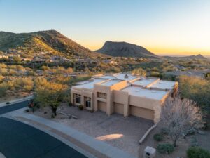
How Drone Photography Changed Real Estate Sales in Tucson
Five years ago, most Tucson real estate listings looked the same. Front-facing photo of the house, some interior shots, maybe a pool photo if you were lucky. Today, buyers scroll through listings on their phones and expect to see their potential new home from every possible angle—including from the air. That shift has fundamentally changed what sells fast and what sits on the market.
At Desert Drones, we work with real estate agents, developers, and property owners across Tucson—from the prestigious Foothills neighborhoods to Marana, from the central historic districts to newer developments in the Oro Valley and beyond. We use FAA-certified drone technology and professional photography techniques to create listing content that genuinely helps properties sell faster and at better prices. It’s not magic. It’s just better marketing.
Why Aerial Photography Matters for Tucson Real Estate
Tucson’s geography is one of its biggest selling points. The Catalina Mountains frame the north side of the city. Saguaro cacti dot the landscape. Properties often feature outdoor living spaces—pools, patios, courtyards—that look dramatically different from the ground than they do from 100 feet in the air.
Buyers want to see the relationship between a home and its surroundings. They want to understand how a property sits in its neighborhood. They want to picture themselves living there. Drone photography does that instantly.
The data backs this up. Real estate listings that include drone photos and video get more online views, receive more buyer inquiries, and typically sell 15-25% faster than listings without aerial content. For properties in the $300,000+ range—common in Tucson’s Foothills and upscale central neighborhoods—that speed matters enormously.
Aerial video also gives potential buyers a sense of movement and scale. They see how the backyard flows, how the driveway approaches the house, how the property relates to nearby homes and terrain. It’s information that static photos simply can’t communicate as effectively.
What Professional Drone Photography Includes
When we photograph a Tucson property, we’re not just flying a drone and snapping pictures. We’re creating a comprehensive visual story of the home and its setting. Here’s what a typical project includes.
We start with detailed flight planning. We identify the best angles to showcase the home’s architecture, yard, pool (if applicable), and surrounding landscape. We plan camera angles that highlight views toward the mountains or other selling features. We scout for potential obstacles and confirm safe flight paths.
On shoot day, we capture multiple photo angles from various altitudes. We shoot video footage of several slow, cinematic passes around the property—including dramatic approaches down the driveway, sweeping views of the backyard, and the relationship of the house to the Tucson skyline and surrounding terrain.
We capture both wide establishing shots and closer detail shots. We photograph in optimal lighting conditions, which usually means late morning or late afternoon when the Arizona sun creates good definition and color without harsh shadows.
After the shoot, we edit and process all imagery. Colors are corrected, skies are enhanced to pop, and any distracting elements are cleaned up. Videos are edited into polished 30-second to 2-minute reels that agents can share on social media, email to clients, or embed on listing pages.
All content is delivered in multiple formats optimized for different platforms—high-resolution JPGs for print, web-optimized images for websites, and video files suitable for YouTube, Facebook, Instagram, and real estate portals.
Showcasing Tucson’s Diverse Neighborhoods From the Air
Every Tucson neighborhood has its own character, and drone photography helps communicate that character to buyers. A Foothills home photographed from above shows how it commands views across the valley, how it integrates with the mountainside terrain, and the spaciousness of the surrounding landscape. The aerial perspective makes a luxury property feel even more exclusive.
Central Tucson properties—often charming older homes with mature trees, historic architecture, and walkable neighborhoods—look entirely different from above. You can capture the relationship to nearby restaurants, parks, and the vibrant neighborhood texture. Newer developments in Marana or Oro Valley show clearly from the air—suburban amenities, planned community features, and how the home fits into the overall neighborhood layout.
Specialty properties benefit hugely from drone photography. A home with a resort-style backyard pool and entertainment area, a property with significant acreage showing horses or agricultural features, a vacant land listing showing topography and boundaries—all of these tell their stories much more effectively from the air than from ground level.
How Aerial Photography Impacts Buyer Decisions
Real estate psychology is interesting. When buyers first search for homes online, most filter by price, bedrooms, and location. But when they look at actual listings, what keeps their attention? Visual appeal. Photos and videos. Properties with professional aerial imagery get clicked on more often, researched more thoroughly, and inquired about more frequently.
From a buyer’s perspective, drone photos answer key questions quickly. How big is this yard really? What’s the neighborhood density like? Does the home have privacy or is it close to neighbors? What can I see from the back patio? Are there good views?
How does the property relate to nearby streets and amenities? These questions matter tremendously in Tucson’s diverse market, where properties range from tight urban lots to multi-acre estates in the foothills.
For agents and sellers, the practical impact is significant. Listings with aerial photos spend less time on the market. They attract more qualified buyers—people seriously interested because they’ve already seen the aerial perspective and confirmed it meets their needs. Multiple offers happen more frequently, which gives sellers better negotiating leverage.
Our Process: From Planning to Delivery
Here’s how we work with Tucson real estate professionals. You contact us with listing details and scheduling preferences. We review the property photos and address to understand the home and location. We discuss any specific features the agent wants to highlight—mountain views, pool area, lot size, unique landscaping, etc. We then schedule a shoot time, preferably in good weather with optimal lighting.
On shoot day, we arrive 30-45 minutes early to review the property, plan flight paths, and confirm airspace clearance. We conduct our pre-flight safety checks. Then we fly multiple passes around the property, capturing photos and video from different altitudes and angles.
The shoot typically takes 30-45 minutes depending on property size and complexity. We brief the agent or homeowner about what we captured and expected delivery timeline.
In post-production, we edit all imagery, color-correct photos, enhance videos with music or titles if desired, and compile everything into deliverables. Agents typically receive a mix of 15-25 still photos and one or more edited video files within 5 business days. Everything is provided in formats ready to use on MLS systems, agent websites, social media, and emails.
Aerial Photography Works Across All Property Types
We’ve photographed everything from cozy neighborhood homes selling for under $200,000 to luxury estates in the Foothills valued well over $1 million. We’ve worked with vacant land listings where aerial perspective shows the true footprint and potential of the parcel.
We’ve photographed multi-unit rental properties that benefit enormously from showing layout and parking. We’ve done aerial shoots for new construction developments, new model homes, and builder showcases across the Tucson market.
Each property has different needs. A small central Tucson bungalow might benefit most from video showing the walkable neighborhood and nearby amenities. A Foothills estate needs dramatic landscape photos emphasizing views and scale. An Oro Valley suburban home should showcase the planned community amenities and space between homes. We tailor our approach to each property’s unique selling points.
Ready to Show Your Tucson Property at Its Best
Whether you’re an agent looking to differentiate your listings, a builder wanting to showcase new homes, or a homeowner preparing to sell, professional aerial photography is one of the highest-ROI marketing investments you can make. Properties look better, generate more interest, and sell faster when buyers can see them from the air.
Ready to add drone photography to your Tucson listings? Visit our Real Estate Photography Services page to see our portfolio and request a quote. Or contact Desert Drones directly to discuss your property and timeline. We’re FAA-certified, experienced with Tucson’s real estate market, and committed to delivering photography that sells homes. Let’s show your property from a perspective your competitors aren’t using yet.