
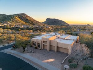
Albuquerque has a landscape unlike almost anywhere else in the country. The Sandia Mountains rise sharply to the east, turning pink and purple at sunset in a way that’s become synonymous with the city. The Rio Grande cuts through the valley floor from north to south. Adobe homes, ranch properties, and high-desert terrain stretch across the metro from the North Valley to the East Mountains.
Drone photography in Albuquerque gives Realtors a way to showcase what makes a property and its surroundings unique. A mountain-view lot in the Foothills, a Rio Grande-adjacent ranch in Corrales, or a custom home in Sandia Heights with panoramic city views all sell more than just the structure—they sell the location. Ground-level photography simply can’t tell that story.
Desert Drones LLC provides FAA Part 107-certified drone photography and videography for Albuquerque Realtors, helping listings stand out in a market where buyers increasingly expect professional aerial content.
Why Albuquerque Real Estate Calls for Aerial Photography
The Sandia Mountains Change Everything
In most cities, a mountain view is simply another feature listed in the property description.
In Albuquerque, buyers can immediately verify those views through aerial photography before they ever schedule a showing.
Homes located in the Foothills, Sandia Heights, Four Hills, and High Desert neighborhoods benefit tremendously from drone imagery that highlights the relationship between the property and the dramatic Sandia Mountain backdrop.
The opposite is also true. If a listing advertises mountain views, aerial photography confirms exactly what buyers can expect. Drone photography doesn’t just enhance marketing—it builds credibility.
The Rio Grande Valley Is Unique
The North Valley, Corrales, and Los Ranchos de Albuquerque feature one of the Southwest’s most distinctive real estate markets, with:
- Horse properties
- Irrigated farmland
- Cottonwood bosque landscapes
- Large custom residential lots
These properties simply cannot be captured properly from ground level.
Drone photography clearly shows:
- Property boundaries
- Agricultural improvements
- Equestrian facilities
- River proximity
- Surrounding open space
For buyers searching for ranches or acreage, aerial photography often becomes the deciding factor in scheduling a showing.
Albuquerque Buyers Are Shopping Online First
New Mexico continues attracting buyers from:
- California
- Texas
- Colorado
- Other western states
Many buyers make their first impressions online.
Drone photography provides spatial context that interior photography cannot deliver.
Wide aerial views showing proximity to the Tramway Corridor, Paseo del Norte, the Rio Grande, or Albuquerque’s West Mesa help buyers understand the property’s location immediately.
Commercial Listings Benefit Too
Commercial real estate throughout Albuquerque—including office buildings, industrial facilities, retail centers, and development sites—benefits significantly from aerial imagery.
Drone photography showcases:
- Traffic visibility
- Access points
- Parking
- Building footprint
- Surrounding businesses
- Neighborhood context
One aerial photograph often communicates more information than dozens of ground-level images.
How the Drone Photography Process Works
Before the Shoot
Once a project is scheduled, Desert Drones reviews the property location and FAA airspace requirements.
Because Albuquerque contains controlled airspace surrounding:
- Albuquerque International Sunport
- Kirtland Air Force Base
certain properties require FAA flight authorization before commercial drone operations can begin.
Desert Drones handles all required approvals, so Realtors never have to worry about paperwork or regulations.
On the Day of the Shoot
Every property receives a customized flight plan.
For Foothills homes, flights emphasize:
- Mountain views
- Elevation
- Scenic surroundings
For ranches and rural properties, flights capture:
- Acreage
- Outbuildings
- Fencing
- Access roads
- Overall property layout
Photography includes:
- High-altitude overview images
- Mid-level neighborhood perspectives
- Close exterior detail shots
Video packages typically include:
- Cinematic approach shots
- Smooth orbit footage
- Property reveal sequences
- Community overview footage
- Scenic landmark shots
After the Shoot
Every project is professionally edited and delivered ready for immediate use.
Deliverables include:
- MLS-ready images
- High-resolution marketing photos
- Social media content
- Zillow-compatible video
- YouTube-ready footage
- Instagram and Facebook formats
No additional editing is required before publishing.
Who Benefits from Albuquerque Drone Photography?
Residential Realtors
Whether listing:
- Starter homes
- Luxury estates
- Custom homes
- Townhomes
professional aerial imagery consistently generates more online engagement and buyer interest.
Today’s buyers increasingly expect aerial content for higher-value listings.
Ranch & Land Specialists
Large rural properties throughout:
- Corrales
- Los Lunas
- East Mountains
- Estancia Valley
are difficult to market using traditional photography alone.
Drone photography allows buyers to fully understand:
- Terrain
- Acreage
- Access
- Improvements
- Overall layout
before visiting in person.
Builders & Developers
Construction companies and developers use drone photography for:
- Community marketing
- Progress documentation
- Investor updates
- Model home promotion
- Pre-sale marketing
Completed developments also benefit from aerial imagery showing neighborhood layout and amenities.
Commercial Brokers
Commercial listings benefit from aerial views highlighting:
- Major road access
- Freeway visibility
- Adjacent businesses
- Parking availability
- Property scale
These perspectives are invaluable for office, retail, industrial, and investment properties.
Why Choose Desert Drones LLC?
FAA Part 107 Certified
Every Desert Drones pilot is FAA Part 107 certified.
This certification ensures:
- Legal commercial operations
- Safe flight practices
- Airspace compliance
- Professional standards
Operating within Albuquerque’s controlled airspace requires experience and regulatory knowledge that uncertified operators simply don’t possess.
Local Albuquerque Experience
Local knowledge matters.
Understanding the best:
- Flight angles
- Time of day
- Lighting conditions
- Mountain positioning
- Seasonal weather
allows Desert Drones to consistently capture Albuquerque properties at their very best.
Professional Deliverables
Every project includes professionally edited images and videos delivered in publication-ready formats.
There are no raw files to organize or additional editing steps before your listing goes live.
Frequently Asked Questions
Does drone photography require permits in Albuquerque?
Properties located within controlled airspace surrounding Albuquerque International Sunport or Kirtland Air Force Base may require FAA authorization. Desert Drones handles every required approval before your scheduled flight.
Can you capture the Sandia Mountains with the property?
Absolutely.
One of the most requested shots in Albuquerque features the property in the foreground with the Sandia Mountains dominating the background. Proper flight planning makes these images possible for many East Side and Foothills listings.
Which properties benefit most from drone photography?
Drone photography is especially valuable for:
- Luxury homes
- Mountain-view properties
- Ranches
- Horse properties
- Acreage
- Commercial buildings
- Development land
- Homes with pools
- Scenic neighborhoods
However, nearly every listing benefits from aerial images showing roof condition, lot size, and neighborhood context.
Can drone video be used on Zillow and social media?
Yes.
Videos are delivered in formats compatible with:
- Zillow
- YouTube
- Instagram Reels
- MLS marketing
Everything is ready for immediate publishing.
Do you serve surrounding communities?
Yes.
Desert Drones proudly serves:
- Albuquerque
- Rio Rancho
- Corrales
- Bernalillo
- Edgewood
- Tijeras
- Los Lunas
- Surrounding New Mexico communities
Contact us for service availability outside the Albuquerque metro area.
Ready to Book Your Albuquerque Drone Photography?
If your listing deserves more than standard ground-level photography, Desert Drones LLC is ready to help.
Professional aerial photography highlights views, property layout, neighborhood context, and location advantages that traditional photography simply can’t capture.
Contact Desert Drones LLC
Phone: (520) 214-8133
Email: JOHN@DESERTDRONESLLC.COM
Website: desertdronesllc.com
Instagram: https://www.instagram.com/desertdronesllc
Serving Albuquerque, Rio Rancho, Corrales, Bernalillo, Edgewood, Tijeras, Los Lunas, and communities throughout New Mexico with FAA-certified drone photography and videography services.