Skip to content
Logo
Facebook-f Instagram Google-plus-g Youtube Linkedin

Call Us Now

520.829.4048

  • Home
  • About
  • Services
    • Construction
    • Industrial/Mining
    • Marketing/Advertising
    • Real Estate
    • Solar
    • Roofing
    • Thermal
    • FPV Drone Videography
  • Location
    • Arizona
      • Phoenix
        • Phoenix Construction Drones
        • Industrial Drones Phoenix
        • Drone Advertising Phoenix
        • Drone Real Estate Photography Phoenix
        • Drone Roof Inspections Phoenix
        • Drone Solar Panel Inspections Phoenix
        • Drone Thermal Inspections Phoenix
        • Drone Photography Phoenix
        • Drone Videography Phoenix
        • Aerial Photography Phoenix
        • Aerial Videography Phoenix
        • FPV Drone Videography Phoenix
      • Tucson
        • Drones For Construction
        • Industrial and Mining Drones
        • Drone Advertising
        • Drone Real Estate Photography
        • Drones For Roofing
        • Drones For Solar Inspections
        • FLIR (Thermal Camera)
        • FPV Drone Videography Tucson
      • Drone Companies Arizona
      • Drone Photography Arizona
      • Drone Videography Arizona
      • Aerial Photography Arizona
      • Aerial Videography Arizona
    • Nevada
      • Las Vegas
        • Las Vegas Construction Drones
        • Industrial Drones Las Vegas
        • Drone Advertising Las Vegas
        • Drone Real Estate Photography Las Vegas
        • Drone Roof Inspections Las Vegas
        • Drone Solar Panel Inspections Las Vegas
        • Drone Thermal Inspections Las Vegas
        • FPV Drone Videography Las Vegas
    • Texas
      • Dallas
        • Construction Drone Services in Dallas & Across Texas
        • Industrial Drone Services in Dallas & Across Texas
        • Drone Advertising Dallas Texas
        • Drone Real Estate Photography Services in Dallas & Across Texas
        • Drone Roof Inspection Services in Dallas & Across Texas
        • Drone Solar Panel Inspection Services in Dallas & Across Texas
        • Thermal Drone Inspection Services in Dallas & Across Texas
        • FPV Drone Videography Dallas
      • El Paso
        • El Paso Construction Drones
        • Industrial Drones El Paso
        • Drone Advertising El Paso
        • Drone Real Estate Photography El Paso
        • Drone Roof Inspections El Paso
        • Drone Solar Panel Inspections El Paso
        • Drone Thermal Inspections El Paso
        • FPV Drone Videography El Paso
    • Colorado
      • Denver
        • Construction Drone Services in Denver & Across Colorado
        • Industrial Drone Services in Denver & Across Colorado
        • Drone Advertising Denver Colorado
        • Drone Real Estate Photography Services in Denver & Across Colorado
        • Drone Roof Inspection Services in Denver & Colorado | Aerial Roof Inspections
        • Drone Solar Panel Inspection Services in Denver & Colorado | Commercial Solar Inspections
        • Thermal Drone Inspection Services in Denver & Across Colorado
        • FPV Drone Videography Denver
    • New Mexico
      • Albuquerque
        • Albuquerque Construction Drones
        • Industrial Drones Albuquerque
        • Drone Advertising Albuquerque
        • Drone Real Estate Photography Albuquerque
        • Drone Roof Inspections Albuquerque
        • Drone Solar Panel Inspections Albuquerque
        • Drone Thermal Inspections Albuquerque
        • FPV Drone Videography Albuquerque
  • Contact
  • Gallery
  • Pilot for Us
  • Blog
    • Construction
    • Real Estate
    • Inspection
    • Videography & Marketing
    • Aerial Photography
  • FAQs
Logo

Call Us Now

520.829.4048

  • Home
  • About
  • Services
    • Construction
    • Industrial/Mining
    • Marketing/Advertising
    • Real Estate
    • Solar
    • Roofing
    • Thermal
    • FPV Drone Videography
  • Location
    • Arizona
      • Phoenix
        • Phoenix Construction Drones
        • Industrial Drones Phoenix
        • Drone Advertising Phoenix
        • Drone Real Estate Photography Phoenix
        • Drone Roof Inspections Phoenix
        • Drone Solar Panel Inspections Phoenix
        • Drone Thermal Inspections Phoenix
        • Drone Photography Phoenix
        • Drone Videography Phoenix
        • Aerial Photography Phoenix
        • Aerial Videography Phoenix
        • FPV Drone Videography Phoenix
      • Tucson
        • Drones For Construction
        • Industrial and Mining Drones
        • Drone Advertising
        • Drone Real Estate Photography
        • Drones For Roofing
        • Drones For Solar Inspections
        • FLIR (Thermal Camera)
        • FPV Drone Videography Tucson
      • Drone Companies Arizona
      • Drone Photography Arizona
      • Drone Videography Arizona
      • Aerial Photography Arizona
      • Aerial Videography Arizona
    • Nevada
      • Las Vegas
        • Las Vegas Construction Drones
        • Industrial Drones Las Vegas
        • Drone Advertising Las Vegas
        • Drone Real Estate Photography Las Vegas
        • Drone Roof Inspections Las Vegas
        • Drone Solar Panel Inspections Las Vegas
        • Drone Thermal Inspections Las Vegas
        • FPV Drone Videography Las Vegas
    • Texas
      • Dallas
        • Construction Drone Services in Dallas & Across Texas
        • Industrial Drone Services in Dallas & Across Texas
        • Drone Advertising Dallas Texas
        • Drone Real Estate Photography Services in Dallas & Across Texas
        • Drone Roof Inspection Services in Dallas & Across Texas
        • Drone Solar Panel Inspection Services in Dallas & Across Texas
        • Thermal Drone Inspection Services in Dallas & Across Texas
        • FPV Drone Videography Dallas
      • El Paso
        • El Paso Construction Drones
        • Industrial Drones El Paso
        • Drone Advertising El Paso
        • Drone Real Estate Photography El Paso
        • Drone Roof Inspections El Paso
        • Drone Solar Panel Inspections El Paso
        • Drone Thermal Inspections El Paso
        • FPV Drone Videography El Paso
    • Colorado
      • Denver
        • Construction Drone Services in Denver & Across Colorado
        • Industrial Drone Services in Denver & Across Colorado
        • Drone Advertising Denver Colorado
        • Drone Real Estate Photography Services in Denver & Across Colorado
        • Drone Roof Inspection Services in Denver & Colorado | Aerial Roof Inspections
        • Drone Solar Panel Inspection Services in Denver & Colorado | Commercial Solar Inspections
        • Thermal Drone Inspection Services in Denver & Across Colorado
        • FPV Drone Videography Denver
    • New Mexico
      • Albuquerque
        • Albuquerque Construction Drones
        • Industrial Drones Albuquerque
        • Drone Advertising Albuquerque
        • Drone Real Estate Photography Albuquerque
        • Drone Roof Inspections Albuquerque
        • Drone Solar Panel Inspections Albuquerque
        • Drone Thermal Inspections Albuquerque
        • FPV Drone Videography Albuquerque
  • Contact
  • Gallery
  • Pilot for Us
  • Blog
    • Construction
    • Real Estate
    • Inspection
    • Videography & Marketing
    • Aerial Photography
  • FAQs
  • Home
  • About
  • Services
    • Construction
    • Industrial/Mining
    • Marketing/Advertising
    • Real Estate
    • Solar
    • Roofing
    • Thermal
    • FPV Drone Videography
  • Location
    • Arizona
      • Phoenix
        • Phoenix Construction Drones
        • Industrial Drones Phoenix
        • Drone Advertising Phoenix
        • Drone Real Estate Photography Phoenix
        • Drone Roof Inspections Phoenix
        • Drone Solar Panel Inspections Phoenix
        • Drone Thermal Inspections Phoenix
        • Drone Photography Phoenix
        • Drone Videography Phoenix
        • Aerial Photography Phoenix
        • Aerial Videography Phoenix
        • FPV Drone Videography Phoenix
      • Tucson
        • Drones For Construction
        • Industrial and Mining Drones
        • Drone Advertising
        • Drone Real Estate Photography
        • Drones For Roofing
        • Drones For Solar Inspections
        • FLIR (Thermal Camera)
        • FPV Drone Videography Tucson
      • Drone Companies Arizona
      • Drone Photography Arizona
      • Drone Videography Arizona
      • Aerial Photography Arizona
      • Aerial Videography Arizona
    • Nevada
      • Las Vegas
        • Las Vegas Construction Drones
        • Industrial Drones Las Vegas
        • Drone Advertising Las Vegas
        • Drone Real Estate Photography Las Vegas
        • Drone Roof Inspections Las Vegas
        • Drone Solar Panel Inspections Las Vegas
        • Drone Thermal Inspections Las Vegas
        • FPV Drone Videography Las Vegas
    • Texas
      • Dallas
        • Construction Drone Services in Dallas & Across Texas
        • Industrial Drone Services in Dallas & Across Texas
        • Drone Advertising Dallas Texas
        • Drone Real Estate Photography Services in Dallas & Across Texas
        • Drone Roof Inspection Services in Dallas & Across Texas
        • Drone Solar Panel Inspection Services in Dallas & Across Texas
        • Thermal Drone Inspection Services in Dallas & Across Texas
        • FPV Drone Videography Dallas
      • El Paso
        • El Paso Construction Drones
        • Industrial Drones El Paso
        • Drone Advertising El Paso
        • Drone Real Estate Photography El Paso
        • Drone Roof Inspections El Paso
        • Drone Solar Panel Inspections El Paso
        • Drone Thermal Inspections El Paso
        • FPV Drone Videography El Paso
    • Colorado
      • Denver
        • Construction Drone Services in Denver & Across Colorado
        • Industrial Drone Services in Denver & Across Colorado
        • Drone Advertising Denver Colorado
        • Drone Real Estate Photography Services in Denver & Across Colorado
        • Drone Roof Inspection Services in Denver & Colorado | Aerial Roof Inspections
        • Drone Solar Panel Inspection Services in Denver & Colorado | Commercial Solar Inspections
        • Thermal Drone Inspection Services in Denver & Across Colorado
        • FPV Drone Videography Denver
    • New Mexico
      • Albuquerque
        • Albuquerque Construction Drones
        • Industrial Drones Albuquerque
        • Drone Advertising Albuquerque
        • Drone Real Estate Photography Albuquerque
        • Drone Roof Inspections Albuquerque
        • Drone Solar Panel Inspections Albuquerque
        • Drone Thermal Inspections Albuquerque
        • FPV Drone Videography Albuquerque
  • Contact
  • Gallery
  • Pilot for Us
  • Blog
    • Construction
    • Real Estate
    • Inspection
    • Videography & Marketing
    • Aerial Photography
  • FAQs

Soaring High: How Aerial Photography is Revolutionizing Industries and Driving Innovation

Soaring High: How Aerial Photography is Revolutionizing Industries and Driving Innovation

drone photos for real estate

The Sky’s the Limit: Unlocking the Full Potential of Aerial Photography


Aerial photography is changing how we see the world. In a survey conducted by *Drone Industry Insights*, the global commercial drone market is expected to reach $43 billion by 2025. This is a huge leap from just a few years ago. Why the surge? Because aerial photography offers unmatched perspectives, practical insights, and transformative benefits across industries. We’re not just talking pretty pictures here, folks. We’re talking data, efficiency, and creative innovation.


What is Aerial Photography?


Let’s break it down. Aerial photography refers to capturing images from an elevated position, typically using drones or aircraft. It’s more than just snapping shots from the sky, though. This method allows for broader coverage and a bird’s-eye view that’s impossible to achieve from the ground. That’s where the magic happens.


From sprawling cityscapes to expansive construction projects, aerial photography can reveal hidden patterns, monitor progress, and offer new angles that the human eye can’t grasp from a traditional viewpoint.


But there’s more to it. It’s about providing actionable insights. Let’s dig deeper into how it impacts various industries and why you need to pay attention.


Construction and Infrastructure: Elevating Efficiency


In the construction sector, time is money. Period. The faster a project is completed, the better it is for everyone involved. That’s where aerial photography steps in as a game-changer. Think about it — rather than sending workers to inspect a vast site by foot, a drone can quickly capture a full-scale image of the area. No climbing scaffolding, no navigating dangerous zones. Just a comprehensive view of the entire site in minutes.


But it doesn’t stop there. With the use of 3D modeling and photogrammetry, construction managers can:


– Track project progress more efficiently.
– Identify potential risks before they become costly mistakes.
– Compare real-time conditions to planned designs, helping to avoid delays.


All this, with just a few clicks of a button. Aerial photography doesn’t just save time; it saves money, too. In fact, some estimates suggest it can cut costs by up to 25% in large-scale projects by improving efficiency and reducing the need for manual inspections.


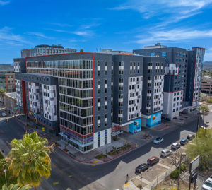
Real Estate: Capturing the Bigger Picture


In real estate, it’s all about location. Or is it? While location is crucial, the ability to showcase a property’s surroundings from an aerial perspective can elevate your listings from ordinary to extraordinary. Aerial photography is no longer a luxury feature — it’s becoming an industry standard.


Imagine scrolling through property listings. Which one would you click on: a house with five basic ground-level photos or one with sweeping aerial views of the neighborhood, local amenities, and the home itself? The choice is obvious.


Drone-shot images allow potential buyers to:


– See the full scope of the property, including land and proximity to nearby features.
– Understand the landscape and layout in a way that ground-level photos simply can’t convey.
– Gain an emotional connection to the property, increasing the likelihood of a sale.


One study by the *National Association of Realtors* found that homes with aerial photography sold 68% faster than those without. For agents, this translates to quicker sales, higher commissions, and more satisfied clients.


Marketing and Advertising: Creativity at New Heights


Let’s face it — we live in a world overloaded with visuals. So how do brands stand out in this cluttered market? By going above it. Quite literally.


Aerial photography adds a fresh, dynamic layer to marketing campaigns, offering views that spark curiosity and leave a lasting impression. Whether it’s capturing a stunning skyline for a tourism ad or showcasing an outdoor event from a new perspective, aerial shots are memorable. They stand out in a sea of sameness.


Here’s how you can make the most of aerial photography in marketing:


1. **Tell a story**: Show more than just the product or service. Use aerial shots to create a narrative that immerses the viewer in the experience.
2. **Highlight scale**: Sometimes, size matters. Capture vast landscapes, large-scale projects, or big events in ways that emphasize their grandeur.
3. **Keep it fresh**: Rotate between aerial shots and close-ups. This adds a dynamic range to your campaign, keeping your audience engaged from every angle.


The impact is immediate. Studies show that visual content drives engagement. Aerial photography adds that extra “wow” factor, which can significantly boost brand awareness and customer interest.


Agriculture: Precision in Every Acre


When it comes to farming, efficiency and precision are the keys to success. Drones equipped with aerial photography technology are revolutionizing how farmers manage their crops, from irrigation planning to yield prediction.


Using specialized sensors, drones can capture multispectral images to:


– Monitor crop health, identifying areas that may need more water or nutrients.
– Detect pest infestations before they spread across large areas.
– Analyze soil conditions, ensuring that farmers can make data-driven decisions.


Precision agriculture, powered by aerial photography, can increase yields by as much as 30% while reducing resource waste. That’s not just smart farming — that’s the future of agriculture.


Surveying and Mapping: Accuracy from Above


Let’s shift gears to another crucial sector — surveying and mapping. Before a construction project begins or a mining site starts extracting resources, accurate data about the land is required. Traditional methods are slow, labor-intensive, and costly.


But with aerial photography, the process is simplified and much more precise. Here’s how it helps:


– **Data Collection**: Drones equipped with high-resolution cameras can cover large areas, collecting thousands of data points in a fraction of the time.
– **Topographic Mapping**: These aerial images are then converted into topographic maps that are essential for planning and development.
– **Environmental Monitoring**: Surveyors can use aerial data to monitor changes in terrain, vegetation, and even water sources.


The accuracy of drone-based surveys can be within centimeters, and they can cover areas that are otherwise hard to access, such as steep hills or dangerous terrains. This leads to better decision-making and more effective land management. In industries where precision is paramount, aerial photography is indispensable.


Filmmaking and Media: The Cinematic Appeal


We can’t talk about aerial photography without giving a nod to the entertainment industry. Aerial shots have become a staple in modern filmmaking, adding depth, scale, and drama to scenes. Think about the sweeping vistas in movies like *The Lord of the Rings* or the epic battle sequences in *Game of Thrones*. Aerial photography gives filmmakers the ability to create cinematic masterpieces with visual storytelling that draws viewers in.


But you don’t need to be Peter Jackson to take advantage of aerial photography. Small production companies and even individual creators can now access drones to capture stunning footage at a fraction of the cost of traditional helicopter shots.


Whether it’s for a commercial, documentary, or independent film, drones make high-quality aerial footage accessible to all, leveling the playing field in an industry where visual impact is everything.


Environmental Conservation: A New Tool for Change


As concerns about climate change and environmental degradation grow, aerial photography is being used as a powerful tool for conservation efforts. Drones allow researchers and environmentalists to monitor wildlife populations, track deforestation, and assess the health of ecosystems with minimal disruption to the natural environment.


Key benefits include:


– **Remote Monitoring**: In remote or dangerous areas, drones provide a safer, cost-effective way to gather data.
– **Reduced Human Impact**: Aerial photography reduces the need for on-the-ground presence, minimizing human interference with delicate ecosystems.
– **Timely Data**: Real-time aerial images help organizations make faster decisions in response to environmental changes.


This is aerial photography at its most impactful — helping to protect our planet.


Actionable Insights for Professionals


Whether you’re in construction, real estate, marketing, or conservation, the potential of aerial photography is vast. But how do you make it work for you? Here are some practical steps:


1. **Invest in the Right Equipment**: Quality matters. Choose drones and cameras that meet the needs of your industry. Not all drones are created equal, and investing in the right gear will make a world of difference.


2. **Work with Skilled Pilots**: It’s not just about flying the drone. Hire certified, experienced pilots who understand how to capture the best angles and deliver actionable insights.


3. **Embrace Software Tools**: Pair your aerial photography with advanced software. Tools like photogrammetry, 3D modeling, and data analytics can help you turn images into useful, actionable data.


4. **Keep Up with Regulations**: The rules surrounding drone use vary by region. Make sure you’re compliant with local laws and FAA regulations to avoid costly fines or project delays.


5. **Tell Your Story**: Whether it’s selling a property or promoting a campaign, use aerial photography to tell a compelling story. Don’t just focus on the images — focus on the narrative they create.


The Future of Aerial Photography


The rapid growth of drone technology means that the possibilities for aerial photography are constantly expanding. As AI, machine learning, and automation continue to evolve, we’ll likely see even more advanced applications in sectors like construction, agriculture, and beyond.


Aerial photography isn’t just about capturing stunning visuals — it’s about using data to make smarter, more efficient decisions. It’s a tool for innovation, and its potential is only beginning to be tapped.


So, what’s next for your industry? Take to the skies and find out!

—

There

Recent Posts

Recent Posts
  • Drone Real Estate Photography in Arizona: Why Aerial Imagery Sells Homes Faster
  • Drone Roof Inspections in Arizona: Faster, Safer, and More Accurate Solutions
  • How Drone Photography Gives Arizona Businesses a Marketing Edge
  • Drone Surveys for Accessory Dwelling Unit Construction
  • Using Drones for Data Cabling Inspection

Tucson Address

  • 5325 N Gerhart Rd
    Tucson, AZ 85745
  • 520-829-4048
  • john@desertdronesllc.com

Phoenix Addresses

  • 2550 W Union Hills Dr Suite 350
    Phoenix, AZ 85027
  • 480.845.0274
  • john@desertdronesllc.com
  • 3707 E Southern Ave
    Phoenix, AZ 85206
  • 480.582.9117
  • john@desertdronesllc.com

Albuquerque Address

  • 500 Marquette Ave NE
    Albuquerque, NM 87108
  • 505.257.6222
  • john@desertdronesllc.com

Las Vegas Address

  • 2300 W Sahara Ave
    Las Vegas, NV 89102
  • 702.707.7066
  • john@desertdronesllc.com

El Paso Address

  • 500 N Oregon St
    El Paso, TX 79901
  • 915.237.1040
  • john@desertdronesllc.com

Denver Address

  • 1801 Wewatta St
    Denver, CO 80202
  • 303.997.3271
  • john@desertdronesllc.com

Dallas Address

  • 18383 Preston Rd
    Dallas, TX 75252
  • 469.949.1776
  • john@desertdronesllc.com

About

  • Home
  • About
  • Construction
  • Industrial/Mining
  • Marketing/Advertising
  • Real Estate
  • Roofing
  • Solar
  • Thermal
  • Contact
  • Gallery
  • Locations
  • Events
  • FAQ

Follow

Facebook-f Instagram Google-plus-g Youtube
Logo
Desert Drones LLC © 2026
520-829-4048