
Technological developments are now essential to obtaining effective and sustainable solutions in the fields of infrastructure planning and land development. Unmanned aerial vehicles (UAVs), sometimes known as drones, have become a revolutionary tool for taking high-resolution pictures, analyzing the environment, and encouraging sustainable lifestyles. This article will examine the use of drones in large preplanned residential land development projects, emphasizing how they can facilitate sustainability and streamline infrastructure planning.
Enhancing Infrastructure Planning:
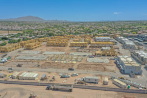
When designing an infrastructure project, information quality and currentness are crucial. Engineers, architects, and urban planners can gain important insights from aerial imagery captured by drones with cutting-edge imaging technology. Drones make it possible to take accurate measurements and create 3D models of the terrain, vegetation, and existing infrastructure, which speeds up project planning. Using this technology, decision-makers can improve infrastructure project functionality, reduce errors, and optimize designs.
Aerial Surveys for Environmental Impact Assessments:
Thorough knowledge of environmental elements and their possible effects is necessary for sustainable land development. In order to undertake environmental impact assessments from an airborne perspective, you need to partner with the right drone service provider. Developers are able to recognize potential hazards, protect delicate habitats, and plan projects that cause the least amount of ecological disturbance. Drones eliminate the need for intrusive on-the-ground surveys by providing faster and more accurate data collecting, encouraging sustainable development methods.
Collaboration and Stakeholder Engagement:
The use of drone technology in land development projects improves stakeholder participation and collaboration. Drones help project teams, investors, and regulatory authorities communicate effectively by gathering fine-grained aerial imagery and producing 3D models. Stakeholders are better able to comprehend the spatial context of planned infrastructure, visualize it, and offer insightful input. This cooperative strategy promotes openness, lessens conflict, and makes sure that the goals of sustainable development are realized.
Minimizing Costs and Timeframes:
Drone use for environmental and infrastructure planning results in significant cost and time savings. Traditional surveying techniques are time-consuming and can involve extensive fieldwork. Drones enable quick data collecting, facilitating more efficient operations and decision-making. Additionally, the accurate data that drones acquire reduces errors, rework, and cost overruns. Drone technology helps developers fulfill strict timelines and complete sustainable land development projects on time by increasing project efficiency.
Drones have become indispensable instruments for planning infrastructure and sustainable land development. They pave the way for effective and sustainable development methods with their capacity to gather aerial photos, carry out environmental impact assessments, and allow stakeholder participation. Developers of large planned communities can optimize infrastructure designs, reduce ecological consequences, and promote a harmonic balance between development and the environment by embracing drone technology. Drones’ contribution to land development will grow in importance as they develop, ushering in a resilient and sustainable future.
Contact Desert Drones LLC today to discuss your upcoming preplanned land developement.