
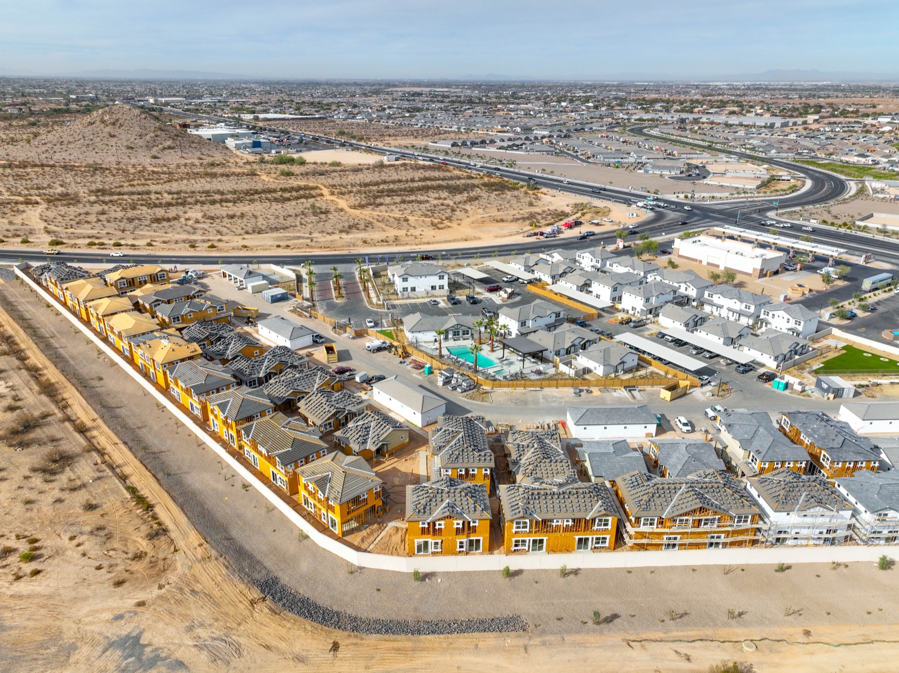
DFW is one of the fastest-growing construction markets in the country right now. You’ve got major mixed-use developments going up in Frisco and McKinney. Industrial and logistics projects spreading across the southern corridor between Dallas and Fort Worth. Multifamily going up in every major suburb. Downtown high-rises. Highway expansion. Data centers. The volume of active construction in this metro is staggering, and developers and GCs who are managing multiple projects simultaneously need something more efficient than weekly site visits to stay on top of progress.
Construction drone dallas site teams use has become standard workflow for serious DFW developers, and for good reason. Aerial progress documentation gives you a complete visual record of what’s happening on site — not just what someone tells you is happening. It’s objective, date-stamped, high-resolution documentation you can share with investors, owners, lenders, and permitting authorities without having to schedule a site visit every time someone needs a progress update.
We’ve worked with DFW developers, general contractors, and project owners across residential, commercial, industrial, and infrastructure projects. Here’s what aerial documentation actually does for active construction projects.
Progress Documentation That Investors and Lenders Actually Want
Construction financing involves regular draw requests, and lenders want to see that the project is progressing as represented before releasing funds. Site inspection visits work, but they’re time-consuming for everyone involved and often result in ambiguous notes rather than clear visual evidence.
Construction drone dallas developers use for draw documentation changes this. Aerial photos and video from a specific date show site conditions at exactly that stage of construction — foundation poured, framing complete, mechanical rough-in done, exterior skin going on. Timestamped, GPS-mapped, unambiguous. Lenders and inspectors can see exactly what they need to see without scheduling a visit. For developers managing multiple projects on draw schedules, this alone pays for the service many times over.
Same logic applies to equity investors and project owners who aren’t on site daily. A monthly progress video — aerial flyover showing site from multiple angles, narrated walkthrough of what’s happened since last month — keeps investors informed and confident without requiring anyone to physically show up.
Site Monitoring and Safety Documentation
Construction sites are dynamic environments where things change fast, and aerial monitoring gives project managers a bird’s-eye view of site conditions that’s hard to get any other way. Equipment placement, material staging, crew distribution, safety setup — you can see all of this from above in a way that’s genuinely useful for project management.
Safety documentation is increasingly important on large DFW construction sites. Site safety audits, OSHA compliance documentation, incident reporting — aerial imagery captures site conditions at specific dates and times, creating a record that’s valuable if questions arise about site conditions during an incident investigation. Some GCs use routine aerial documentation as part of their risk management program specifically because it creates a timestamped visual record of site conditions that’s hard to dispute.
We’ve done site monitoring for Dallas-area projects where the GC wanted weekly aerial coverage — same flight path, same angles, every week — so they could compare progress across weeks in a consistent format. That kind of systematic documentation makes milestone reporting straightforward and gives project managers clear visibility into pace versus schedule.
Before, During, and After: A Complete Project Record
The most valuable thing about consistent aerial documentation across a construction project is the complete before-during-after record it creates. Pre-construction site documentation establishes existing conditions — valuable for legal protection if questions arise about what the site looked like before work began, and useful for environmental compliance in some project types.
During construction, regular progress documentation creates a chronological record that’s useful for multiple purposes: claims documentation if disputes arise about scope or schedule, marketing content for future projects, training materials, and investor reporting. Post-construction, final aerial documentation shows the completed project in its best light — useful for marketing, leasing, and as a reference for future maintenance needs.
We’ve worked with DFW developers who use final aerial imagery and video in their marketing for subsequent projects. A polished aerial video of a completed industrial park or mixed-use development makes a compelling portfolio piece when you’re pitching the next deal to investors or lenders.
Industrial and Logistics Projects in DFW’s Southern Corridor
The stretch between Dallas and Fort Worth along I-20 and I-30 has become one of the most active industrial development corridors in the country. Warehousing, distribution, light manufacturing, last-mile logistics — construction is constant. These projects have large footprints, complex site logistics, and multiple stakeholders who need visibility without being on site.
Construction drone dallas logistics projects benefit from aerial documentation in a specific way: site scale. An industrial project covering 40 or 50 acres can’t be meaningfully documented from the ground. You need aerial perspective to see how the site is organized, how phasing is progressing across the full footprint, how infrastructure is being installed, and how the finished project relates to its surroundings, access roads, and adjacent properties.
We’ve covered industrial construction across the DFW metro, including projects near Alliance Airport in Fort Worth, the Great Southwest Industrial District in Grand Prairie, and the southern logistics corridor. We understand the scale of these projects and how to document them in ways that are useful to developers and lenders.
Residential Subdivision and Multifamily Development
DFW’s residential construction market has been in overdrive for years — master-planned communities in Celina, Anna, and Prosper; infill multifamily in Dallas proper; mixed-use in Plano and Frisco. Aerial documentation serves different purposes at this scale than on commercial projects, but it’s equally valuable.
For subdivision development, aerial photography shows lot layout, infrastructure progress, model home placement, and community build-out progress in a single frame. Marketing teams use these images to show buyers where their lot is in context of the broader community, which amenities are near them, and what the community will look like when complete. Developers use the same images for investor reporting and homebuilder coordination.
For multifamily projects, aerial progress documentation is especially useful during vertical construction — you can see floor-by-floor progress in a way that ground photos can’t capture. Framing, mechanical rough-in, exterior skin progress — all clearly visible from above at the project’s peak construction phase.
Permitting Documentation and Regulatory Compliance
Some DFW construction projects require aerial documentation as part of permitting or environmental compliance. Grading plans, drainage documentation, wetland compliance, SWPPP inspections — aerial imagery and video provide the documentation authorities need in a format that’s easy to share and archive.
We’ve supported DFW projects where city or county inspectors wanted aerial documentation of drainage implementation, grading completion, or erosion control measures as part of permit closeout. Having a drone operator who can produce properly formatted aerial documentation, including GPS coordinates and accurate timestamps, makes this process significantly smoother than trying to document large-footprint sites from the ground.
Working with DFW’s General Contractors and Project Owners
Dallas has serious construction firms managing serious projects, and they expect professional service and reliable delivery. We work around active construction schedules, coordinate with site superintendents, and deliver documentation in formats that work for the project team — not just nice-looking videos that aren’t useful on a job site.
Reports come back in two to three business days. We deliver raw footage for in-house editing, edited progress videos ready for investor distribution, annotated still photos for permitting or loan draws, and geographic data overlays when projects require it. Our pilots understand active construction environments — we’re not disrupting work, we’re fitting into it.
Schedule Your DFW Site Documentation
Residential subdivision, industrial development, multifamily, mixed-use, or infrastructure — if it’s under construction in the DFW metro, aerial documentation belongs in your project workflow. Construction drone dallas GCs and developers count on gives you the visibility and documentation that modern construction management requires.
FAA-certified, commercially insured, experienced with DFW’s development landscape and what different project types and stakeholders actually need from aerial documentation.
Contact Desert Drones LLC to set up site documentation for your Dallas-area project. Visit desertdronesllc.com or call for pricing on DFW construction monitoring and progress documentation services.