
Ground-level listing photos work fine for a lot of markets. Here, they leave too much out.
The Franklins. The desert terrain. The way a lot sits on a hillside, or opens onto an arroyo, or faces west so the light hits it differently in the afternoon than it does at noon. These are the things that make a property worth what it’s worth — and they’re nearly impossible to show from street level. A drone shot at 300 feet tells that story in a single frame.
Aerial listing photography isn’t new. But the expectation has shifted. Buyers — especially buyers coming in from out of market, which is a big chunk of who’s purchasing here — now expect aerial coverage on any listing they’re seriously considering. If it’s not there, they assume there’s something worth hiding, or they simply move on to the next property that does have it. We’ve been shooting real estate aerials for Realtors in this area long enough to see that pattern play out over and over.
This post is for Realtors who are still on the fence about whether aerial photography is worth adding to their listing packages — or who know it’s worth it but haven’t found a reliable local operator they trust to do it right.
The Landscape Here Does the Selling If You Show It
Most of the country’s real estate markets are flat. Subdivisions on flat ground look pretty similar from the air whether you’re in Ohio, Georgia, or suburban Dallas. The aerial shot adds context, but it’s not transformative.
This market is different. The terrain is dramatic in a way that matters to buyers. The Franklin Mountains run right through the middle of the city, and properties on either side of them — east mesa, west side, upper valley, the hills — have completely different characters. A home that’s a ten-minute drive from downtown but sits up on the edge of a desert ridge with views across the basin looks like a completely different kind of property from the air than it does from the street.
The aerial shot isn’t just nice to have. It’s the difference between a buyer understanding what they’re looking at and a buyer scrolling past.
Then there’s the buyer pool itself. A significant share of buyers in this market are relocating — military families getting orders to Fort Bliss, federal employees, people moving from other parts of Texas or New Mexico. They don’t have the local knowledge to visualize what the different neighborhoods feel like, how close a west-side home is to the mountains versus one in the northeast, or what the commute to Biggs or Fort Bliss looks like from a given part of town. Aerial photography — especially neighborhood-level aerials that show surrounding streets, nearby commercial, and geographic context — helps those buyers make sense of a property before they ever set foot in the city.
It also helps with the properties that ground-level photography just can’t do justice to. Hillside homes with retaining walls and xeriscape landscaping. Acreage properties in the upper valley near the river. New construction lots in master-planned communities where buyers want to see where their lot sits relative to the amenities and the street. Horse properties in Canutillo or the Montana Vista area where the land itself is the main feature. All of these read better — sometimes dramatically better — from the air.
What a Real Estate Drone Shoot Actually Produces
It’s worth being specific about what you’re actually getting when you hire a drone photographer for a listing, because there’s a big range in quality and deliverables across different operators.
A standard aerial package for a listing here includes 15 to 25 edited still images. That typically means a wide establishing shot that shows the property in its neighborhood context, a top-down nadir view that shows the lot shape and footprint clearly, angled shots from multiple directions, backyard and pool coverage if the property has those features, and at least one hero shot that puts the mountains or city backdrop in the frame. For most listings, that’s the core package — and it’s enough to make a real difference on a listing page.
For higher-end listings — anything over $500K, or any property with significant land or distinctive features — we almost always recommend adding a short cinematic video. A 60 to 90 second aerial video that moves through the property and its surroundings consistently outperforms static photos for engagement on Zillow, Realtor.com, and social. Out-of-market buyers especially use video to narrow their shortlist before making the trip out, and a well-shot aerial video can do more to get someone on a plane than a full gallery of ground-level photos.
Timing matters a lot here, more than in a lot of other markets. The light in the Chihuahuan Desert is genuinely remarkable in the early morning and late afternoon — warm, directional, and flattering to virtually any exterior style, whether it’s stucco, brick, or adobe. Midday shoots in this climate tend to produce flat, washed-out imagery that doesn’t do the property any favors. We schedule every shoot around the light, and for most listings that means late afternoon with the option of a dusk sequence if the property has exterior lighting worth capturing.
Airspace Here Is More Complex Than Most Markets — Here’s What You Need to Know
This is something worth understanding if you’re hiring any drone photographer in this area, because the airspace situation is genuinely different from most Texas markets.
Fort Bliss creates controlled airspace over a significant portion of the northeast side of the city. The base boundary and its associated restricted areas mean that properties in Northeast, the upper Rim Road corridor, and anywhere near the installation require airspace authorization before any drone can legally fly. On top of that, the airport’s Class C airspace covers a wide swath of central and east areas of the city, which also requires authorization through the FAA’s LAANC system.
A licensed, FAA Part 107 certified operator — which is what you need for any commercial drone work — handles all of this as standard procedure. Before every shoot, we check the airspace, file for LAANC authorization where it’s required, and confirm we’re clear to fly. For most locations it’s a straightforward process. For properties near Bliss or the airport, it takes an extra step, but it’s fully manageable.
The reason this matters for Realtors: if you’re hiring someone without Part 107 — a friend with a drone, a cheap Craigslist operator — you’re taking on liability for imagery that was collected illegally. That’s not a technicality. It’s a real exposure, especially on listings near the installation where the FAA and military take airspace violations seriously. Every shoot we do is authorized. You don’t have to think about it, but you should know it’s being handled.
A Few Things That Make a Shoot Go Better
After a few years of shooting listings in this area, there are some practical things we’ve learned that make a real difference in what the final images look like.
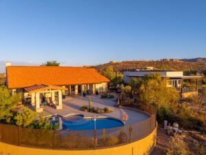
Exterior staging matters more than most sellers realize. From the air, things that are invisible at street level become very visible — trash cans left out, garden hoses coiled on the driveway, patio furniture that’s been through a few too many monsoon seasons, a car parked at a weird angle in front. A quick exterior walkthrough before the shoot to clear and tighten things up makes a real difference in how the finished images look.
Pools, covered patios, and outdoor kitchens are worth calling out specifically. In this market’s climate, those features are genuine selling points, and they read beautifully in aerial photography in a way that ground-level photos can’t match. A top-down pool shot shows the full layout — the decking, the landscaping, the relationship between the pool and the covered area — in a way that one angled photo from the yard just can’t.
Finally, if the property has a view, we’ll almost always recommend a twilight shot. City lights from the basin, the mountains going dark against the sky, the glow of the street grid below — it’s some of the most compelling listing imagery we produce, and for the right property it can be the shot that closes the deal.
Book a Listing Shoot with Desert Drones LLC
We’re local, we’re FAA Part 107 certified, and we know this market. Whether you have one listing coming up or you’re looking for a consistent aerial partner for your business, reach out and let’s talk through what you need.
Contact Desert Drones LLC
- Website: desertdronesllc.com
- Phone: (915) 237-1040
- Email: desertdronesllc@gmail.com