
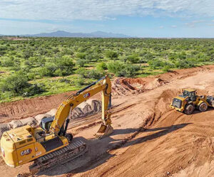
Large-scale infrastructure projects are entering a new era of efficiency, safety, and precision, and the future of construction drones is at the center of this transformation. From highways and bridges to utilities, solar farms, and large-scale commercial developments, drones are rapidly becoming essential tools for modern infrastructure planning and execution. For developers, engineers, and contractors working in the Desert Southwest, drone technology offers unparalleled advantages in scale, speed, and accuracy—especially when deployed by experienced providers like Desert Drones LLC.
As infrastructure demands grow and project timelines tighten, traditional ground-based methods struggle to keep pace. Drones are filling that gap, delivering real-time aerial data, actionable insights, and cost savings across every phase of large-scale construction.
Why Drones Are Essential for Large-Scale Infrastructure Projects
Infrastructure projects often span hundreds—or even thousands—of acres. Managing that scale with manual surveys, scaffolding, or ground crews alone is time-consuming, costly, and risky. Drones solve these challenges by offering rapid aerial access to vast and hard-to-reach areas.
Key advantages include:
-
Comprehensive site visibility
-
Faster data collection
-
Improved decision-making
-
Reduced labor and equipment costs
-
Enhanced safety compliance
In regions like the Desert Southwest, where terrain, heat, and distance pose additional challenges, drone technology becomes even more valuable.
The Role of Drones Across the Infrastructure Lifecycle
1. Pre-Construction Planning and Site Analysis
Before the first piece of equipment hits the ground, drones play a crucial role in site evaluation. High-resolution aerial imagery and mapping allow stakeholders to understand terrain, access points, elevation changes, and environmental constraints.
For large-scale infrastructure projects such as highways, pipelines, or utility corridors, drone surveys help teams:
-
Identify grading challenges
-
Plan efficient access routes
-
Reduce design errors
-
Improve project feasibility assessments
This early-stage intelligence sets the foundation for smoother project execution.
2. Progress Monitoring at Scale
Tracking progress across massive infrastructure sites is one of the most powerful applications of drone technology. Regular aerial flights provide consistent visual documentation that allows project managers and stakeholders to monitor timelines and identify potential delays.
Drones enable:
-
Weekly or monthly progress documentation
-
Clear communication between teams and investors
-
Visual proof of completed milestones
-
Faster response to construction bottlenecks
For large projects with multiple contractors and phases, drone progress tracking ensures everyone stays aligned.
3. Enhanced Safety on Complex Job Sites
Safety is a top priority on large infrastructure projects, where workers often operate near heavy equipment, elevated structures, and hazardous conditions. Drones significantly reduce the need for personnel to physically inspect dangerous areas.
Using drones for infrastructure safety helps:
-
Minimize worker exposure to risk
-
Identify safety issues before accidents occur
-
Document compliance with safety regulations
-
Improve overall site awareness
By conducting aerial inspections instead of manual checks, contractors reduce liability while maintaining high safety standards.
4. Infrastructure Inspections Made Faster and Smarter
Infrastructure assets such as bridges, towers, roadways, and pipelines require regular inspections—both during and after construction. Traditionally, these inspections involve lane closures, scaffolding, or specialized equipment.
Drones streamline this process by capturing detailed aerial imagery quickly and efficiently. This approach is especially valuable for:
-
Bridge and overpass inspections
-
Transmission line and utility infrastructure
-
Large-scale concrete structures
-
Solar and renewable energy installations
The result is faster inspections with minimal disruption and lower costs.
The Future of Construction Drones in Infrastructure Development
As drone technology continues to advance, its role in infrastructure projects will only expand. The future of construction drones is being shaped by innovations that make aerial data more accessible, more accurate, and more actionable than ever before.
Smarter Data Collection
Modern drones capture ultra-high-resolution imagery that provides clear visual records of massive job sites. This allows project teams to zoom in on specific areas without losing the big-picture context—an essential capability for large-scale infrastructure management.
Faster Decision-Making
With rapid aerial updates, stakeholders no longer wait days or weeks for reports. Drone data supports quicker decisions, helping teams address issues before they escalate into costly delays.
Cost Control at Scale
Infrastructure budgets are massive, and even small inefficiencies can lead to significant overruns. Drones reduce costs by:
-
Cutting survey and inspection time
-
Minimizing equipment rentals
-
Reducing rework caused by incomplete data
-
Improving coordination across teams
Over the lifespan of a large project, these savings add up.
Why the Desert Southwest Benefits Most from Drone Technology
Large infrastructure projects in desert environments face unique challenges: extreme heat, remote locations, uneven terrain, and vast distances between work zones. Drone services from Desert Drones LLC are uniquely suited to these conditions.
Benefits include:
-
Aerial access to remote sites without added travel time
-
Reduced exposure of workers to harsh environmental conditions
-
Efficient coverage of expansive desert landscapes
-
Consistent documentation despite challenging terrain
For infrastructure developers operating in the Southwest, drones are no longer optional—they’re a competitive advantage.
Why Choose Desert Drones LLC for Infrastructure Projects
Not all drone providers are equipped to handle the complexity and scale of major infrastructure developments. Desert Drones LLC specializes in professional drone services designed for large construction and infrastructure projects.
What sets Desert Drones LLC apart:
-
Expertise in large-scale project documentation
-
Reliable, consistent flight operations
-
Clear, actionable aerial visuals
-
Experience working in desert and remote environments
-
Focus on construction and infrastructure use cases
Whether it’s a multi-mile roadway project or a massive commercial development, Desert Drones LLC delivers aerial insights that help teams build smarter and faster.
Drones as a Long-Term Infrastructure Investment
As infrastructure spending increases nationwide, drone technology is becoming a long-term investment rather than a short-term tool. Agencies and contractors that adopt drones early gain:
-
Better project transparency
-
Improved accountability
-
Stronger stakeholder communication
-
Higher-quality documentation
The future of construction drones is not about replacing people—it’s about empowering teams with better information at the right time.
Final Thoughts: Infrastructure Is Going Aerial
Large-scale infrastructure projects demand precision, speed, and efficiency. Drones meet these demands by providing a level of visibility and insight that traditional methods simply can’t match. As the industry continues to evolve, drone technology will remain a driving force behind safer, smarter, and more cost-effective infrastructure development.
For companies looking to stay ahead of the curve, partnering with a trusted drone service provider like Desert Drones LLC is a strategic move toward the future of construction.
Contact Desert Drones LLC
Ready to elevate your next infrastructure project with professional drone services?
Desert Drones LLC
📞 Phone: (520) 214-8133
🌐 Website: https://desertdronesllc.com
📸 Instagram: https://www.instagram.com/desertdronesllc
📧 Email: JOHN@DESERTDRONESLLC.COM