
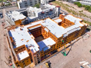
El Paso is building. And it’s been building at a pace that doesn’t get nearly as much national attention as the scale of the work deserves.
Fort Bliss is one of the largest Army installations in the country, and the construction and infrastructure activity on and around the base is substantial. The Medical Center of the Americas campus on the east side of downtown has been expanding steadily for years. UTEP continues to develop its campus footprint. The west side of the city, from Montecillo out toward Vinton, has seen significant residential growth. And the industrial corridors along I-10 and along the US-Mexico border have been adding manufacturing and logistics capacity as nearshoring trends continue to drive investment into the Borderplex region.
All of that construction needs documentation. Desert Drones LLC provides FAA-certified aerial photography and videography for construction projects across El Paso, giving project owners, general contractors, homebuilders, and developers the professional aerial record they need at every stage of the job.
Construction in the Borderplex Region
El Paso’s construction market is shaped by its unique geography and economic position. Sitting at the intersection of Texas, New Mexico, and Chihuahua, Mexico, the city functions as a major logistics, manufacturing, and military hub in ways that drive construction activity differently than most comparable-sized metros.
Nearshoring has been a major driver of industrial construction along the border corridor. As companies look to move manufacturing closer to US markets, the Juarez-El Paso industrial park ecosystem — one of the largest maquiladora concentrations in North America — continues to grow. That growth spills across the border in the form of distribution facilities, logistics warehouses, and support infrastructure on the El Paso side of the Rio Grande.
The Hunt Companies’ developments downtown, the continued expansion of the Hospitals of Providence system, and the residential growth in the Upper Valley and Mission Hills area all represent active construction markets where aerial documentation adds value at every phase.
Fort Bliss and Military-Adjacent Construction
Fort Bliss is the dominant physical feature of east El Paso, covering nearly 1.1 million acres across Texas and New Mexico. Construction and infrastructure activity on the installation itself is significant and ongoing, and the communities that have grown up around the base — areas like Northeast El Paso, Horizon City, and Fabens — have seen residential development that tracks closely with military population growth.
Civilian construction projects near Fort Bliss require careful airspace coordination. Biggs Army Airfield, which sits within the Fort Bliss complex, is an active military airfield with airspace that extends into the civilian construction zones east of the city. We handle LAANC coordination and military airspace notification before every flight in these areas — it’s part of our standard process for El Paso work, not an afterthought.
Commercial and Industrial Construction Documentation
El Paso’s commercial construction market is concentrated in several specific corridors. The area around I-10 and US-54 (the Patriot Freeway) has been one of the most active commercial development zones in the city for the past decade. The TransMountain Road and Transmountain Loop area on the northwest side is seeing retail and mixed-use development as the population center of gravity shifts west. And the downtown core, anchored by the Medical Center of the Americas and the El Paso Children’s Hospital, continues to attract medical office and professional development.
For commercial developers in these markets, aerial documentation serves lender reporting, investor marketing, and project record-keeping. For general contractors, it creates a third-party documented visual record of site conditions and construction progress that protects everyone when questions come up after the fact.
Industrial construction along the border corridor, particularly in the Westway and Butterfield Trail Industrial Park areas, benefits from aerial documentation that shows site scale, access, and infrastructure in the comprehensive way that ground-level photography simply can’t deliver. For properties designed to attract distribution or manufacturing tenants, aerial imagery is standard marketing material.
Residential Construction in El Paso
El Paso’s residential construction market has been concentrated in the west and northwest parts of the city — the Westside, Upper Valley, and the Montecillo development have all seen consistent homebuilding activity. The northeast, particularly around the Loop 375 Border West Expressway, has also seen residential growth tied to the Fort Bliss population.
For production homebuilders, aerial progress photography serves the same core functions as in any high-growth market: marketing content that sells homes and lots before they’re finished, community progress imagery for investor and lender reporting, and a visual timeline of the project from groundbreaking through community completion.
We offer monthly and bi-monthly construction progress packages for active residential communities, with consistent flight paths and camera angles that make every update directly comparable to the last. The result is a visual record of your project that’s useful for internal reporting, external marketing, and long-term documentation.
How We Fly El Paso
El Paso sits in a complex airspace environment. El Paso International Airport generates controlled airspace that covers a significant portion of the central and northeast city. Biggs Army Airfield at Fort Bliss adds military airspace over the east side. And the proximity to the Mexican border creates additional airspace considerations that require careful coordination.
Our pilots are FAA Part 107 certified and have specific experience operating in El Paso’s airspace environment. We file LAANC authorization before every flight in controlled airspace and maintain communication with El Paso International as needed. For projects near Fort Bliss, we follow the required military airspace notification protocols. You don’t have to manage any of that — we do it, we document it, and we keep the authorization records on file.
Most El Paso metro jobs can be scheduled within 3 to 5 business days. We work around the morning wind conditions that can affect the Franklin Mountains area and plan flight windows accordingly.
Deliverables and Turnaround
Every construction shoot includes 4K video edited and color-graded for immediate use, high-resolution stills at multiple altitudes and angles, and digital delivery within 24 to 48 hours. Files are formatted for use in presentations, marketing materials, lender reports, and social media.
For ongoing projects with regular documentation needs, we establish a consistent delivery schedule so aerial updates arrive on a predictable cadence that fits your reporting cycle.
Ready to Document Your El Paso Project?
From industrial construction along the border corridor to residential communities on the Westside to commercial development near the Medical Center of the Americas, Desert Drones LLC delivers professional aerial construction documentation across El Paso and the surrounding region.
Get a Quote for El Paso Construction Photography
Call or book online. We’ll set up a documentation schedule that fits your project timeline and have the first deliverables in hand within 48 hours of the first flight.
Frequently Asked Questions
Can you fly near Fort Bliss for construction photography in El Paso?
Yes, with proper coordination. Biggs Army Airfield at Fort Bliss generates military airspace over the east side of El Paso. We follow all required military airspace notification protocols before every flight in these areas. We have specific experience operating in the El Paso airspace environment and handle all coordination as part of our standard process.
How do you handle airspace near El Paso International Airport?
El Paso International Airport generates controlled airspace that covers a significant portion of the city. We file LAANC authorization before every flight in the airport’s airspace and keep authorization documentation on site. For most El Paso metro projects, LAANC adds 24 to 48 hours of lead time to scheduling.
What is the turnaround time for El Paso construction deliverables?
Edited 4K video and high-resolution photography are delivered digitally within 24 to 48 hours of the flight. For scheduled progress packages, we establish a consistent delivery cadence that aligns with your reporting cycle.
Do you cover the West Texas and New Mexico areas surrounding El Paso?
Yes. In addition to the El Paso metro, we cover Las Cruces, Horizon City, Fabens, and the broader Borderplex region. Extended service is available to Midland and Odessa — contact us for scheduling and pricing.