Trustindex verifies that the original source of the review is Google. Desert Drones is fantastic to work with! They do an incredible job bringing our vision to life and capturing our projects in a way that truly showcases the work being done. Highly recommend their team. Thanks again, Desert Drones!Trustindex verifies that the original source of the review is Google. Desert Drones is awesome to work with! They help bring our vision to life and showcase our work in the best way possible. Highly recommend them to anyone looking for quality drone services. Thanks, Desert Drones!Trustindex verifies that the original source of the review is Google. John and team are the consummate professionals! Very reliable, quick, and high quality deliverables!Trustindex verifies that the original source of the review is Google. Professional, efficient, and easy to work with. The team delivered clean, high-quality aerials and communicated clearly throughout the project. One of the best drone service providers we’ve worked with in the Phoenix area.Trustindex verifies that the original source of the review is Google. Needed work done quickly for drone photography. They responded quickly and knew exactly what was required and explained it well. They provided great customer service and got me exactly what I needed, when I needed. Finally found my Drone guys!Trustindex verifies that the original source of the review is Google. John was a professional and very knowledgeable. He made the process of getting drone footage seamless and did an exceptional job. The speed of completion along with quality of his work was excellent. Highly recommend using them if...Trustindex verifies that the original source of the review is Google. John is true professional. Every time we need some drone photography or videography done John is excited to take on the project. From midnight fireworks displays to busy sections of the city with all kinds of obstacles, working with Desert Drones never fails to hit the mark.Trustindex verifies that the original source of the review is Google. Absolutely amazing experience with Desert Drones. They did a shoot for my business and I must say, they made my product really speak for itself! The aerial shots were stunning and perfectly captured every special moment. John was very professional, punctual, and easy to work with. Highly recommend them for any event coverage—you won’t be disappointed!Trustindex verifies that the original source of the review is Google. Great company and amazing aerial photography!Trustindex verifies that the original source of the review is Google. John took care of the interior and exterior drone footage for our manufacturing facility in Tucson. He was great to work with! Very knowledgeable, answered all our questions, and shot some great videos. He was also quick to respond to emails and calls throughout the whole process. I would definitely use Desert Drones again in the future.
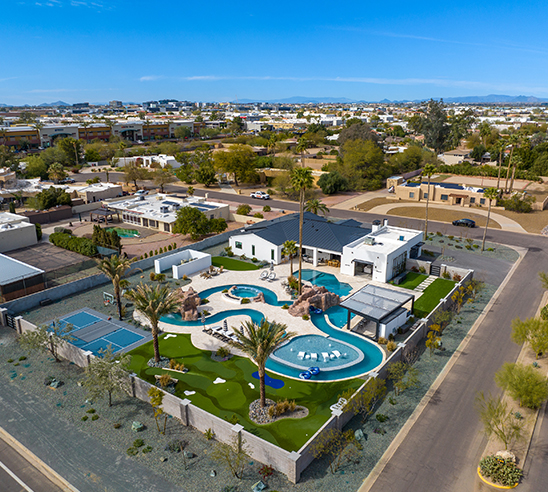
Great real estate marketing starts with compelling visuals — and nothing delivers impact like aerial photography. Our pilots fly premium drones to capture high-resolution aerial shots that highlight property features, land contours, surroundings, and scale. These images are perfect for MLS listings, brochures, web pages, and social media ads.
For example, a Phoenix home in Paradise Valley saw its listing views spike after we flew elevated exterior shots that revealed landscaping, pool layout, and proximity to Camelback Mountain. In competitive neighborhoods like Arcadia, these aerial views showcase features traditional photos miss.
We also coordinate with your ground photographer to capture twilight, interior, and architectural angles — creating a cohesive visual narrative from ground to sky. Together, these images tell potential buyers not just what a property looks like, but what living there feels like.
Video is the next frontier of property marketing. At Desert Drones, we deliver 4K cinematic drone videos that guide prospective buyers through properties in motion. These fly-over tours help buyers visualize entry points, yard flow, neighborhood context, and key amenities — beyond what static photos can show.
We integrate smooth transitions, gimbal stabilization, and branded overlays so clients get polished, professional video ready for websites, YouTube, and social ads. In Phoenix’s hot real estate sectors (Scottsdale, Tempe, Gilbert), buyers often decide within seconds — and a quality video can make your listing the one they click.
In many Phoenix deals, context is king. Properties perched on hills, surrounded by washes, or with irregular terrain require more than pretty photos — they need context-aware data. Desert Drones produces orthomosaic maps, 3D site models, and aerial context overlays to help buyers and developers understand lot functionality, buildable area, roof lines, and adjacent zoning.
These deliverables are especially valuable for high-end builds, infill lots, and custom home sites in north Phoenix, Scottsdale, and Paradise Valley. We provide deliverables compatible with architectural software and bilingual overlays (e.g. property lines, elevation lines) so agents and clients both benefit.
Your drone content should drive leads, not just look nice. Desert Drones crafts marketing-ready content packages tailored for Phoenix real estate. We pair aerial photography and video with social media clips, teaser reels, photo galleries, and branded assets so agents can roll out cohesive campaigns instantly.
Our packages include versions optimized for Instagram, Facebook, TikTok, and Google Ads — with proper ratios, durations, and compression. Whether you’re launching a new development in Chandler or promoting a luxury home in Scottsdale, our content helps listings gain traction across digital channels.
When your reputation and commissions are on the line, you need a partner who delivers reliably. Desert Drones offers:
We’ve helped agents and developers across Mesa, Glendale, Tempe, and the Phoenix metro close listings faster and at higher price points. Let us bring that advantage to your next property.
Yes — as long as flights follow FAA Part 107 rules. We also check local HOA, city, and airspace restrictions (especially near Sky Harbor, McDowell Mountain, Estrella Mountain, etc.).
Typically 24–48 hours is enough. For busy areas or zoning permits, 2–3 days buffer gives us breathing room.
Yes, when weather and schedule permit. We coordinate with your ground photographer so your visual package is cohesive.
We shoot 20–48 MP stills and export 4K HDR video. Our images are clean, color-balanced, and retouched for listing performance.
Yes — studies show listings with video get 30–50% more views. Agents report faster closings and better offers when aerial tours are part of their marketing.